Difference between revisions of "Oregon Route 231 (Oswego-Wilsonville)"
(Initial creation of OR-231 (1930s) page) |
(Added routebox and full known route history at this point) |
||
| Line 1: | Line 1: | ||
| − | This | + | {{Routebox|type=OR|number=231|shield_variant=1932|name=Oregon Route 231|highway=Clackamas County Market Road #12|map=OR_231_1934-map.jpg|maintained_by=Clackamas County|length=≈10.5|created=1934|removed=???|start_terminus_dir=North|start_terminus={{Jct|type=US|number=99|shield_variant=1926|page=US Route 99|route=US-99}} in Oswego|end_terminus_dir=South|end_terminus={{Jct|type=OR|number=217|shield_variant=1932|page=Oregon Route 217|route=OR-217}} in Wilsonville|prev_route={{Jct|type=OR|number=230|page=Oregon Route 230|route=OR-230}}|next_route={{Jct|type=OR|number=231|shield_variant=1948|page=Oregon Route 231 (Glenwood-Divide)|route=OR-231 (195?)|align=right}}}} |
| + | '''Oregon Route 231''' was a secondary state route assigned in 1934 between [[US Route 99|US-99]] in Oswego (now [[Oregon Route 43|OR-43]] in Lake Oswego) and [[Oregon Route 217|OR-217]] in Wilsonville. It was designated along '''Clackamas County Market Road #12''', but it is unknown at this time whether or not the route number was ever posted along the road. Today, the road is known as McVey Avenue in Lake Oswego, SW Stafford Road in Clackamas County, and SW Wilsonville Road in Wilsonville. | ||
| + | |||
| + | ==History== | ||
| + | |||
| + | Clackamas County Market Road #12 was built at some point prior to 1880 and was known colloquially as the "Oswego Road,"<ref name="oreg_1880-01-14">''The Daily Oregonian.'' "The Recent Storm," 14 January 1880, p. 1</ref> "Oswego-Wilsonville Road"<ref name="oreg_1923-10-28">''The Sunday Oregonian.'' "Oswego-Wilsonville Road Paving Is Progressing," 28 October 1923, p. 3</ref> and "South Oswego-Wilsonville Road"<ref name="oreg_1928-11-04">''The Sunday Oregonian.'' "Portland-Salem Super-Highways," 4 November 1928, p. 1</ref>. It had one major bridge over the Tualatin River, the Shipley Bridge near Wanker's Corner, that was also built prior to 1880; the original bridge was washed away in a massive storm on January 9th of that year<ref name="oreg_1880-01-14" /> and was replaced soon after with a wooden covered bridge<ref name="oreg_1938-10-12">''The Sunday Oregonian.'' "Bridge Grant Accepted," 12 October 1938, p. 4</ref>. The road was paved in sections, starting north of Shipley Bridge around 1923<ref name="oreg_1923-10-28" /> and completed by 1928<ref name="oreg_1928-11-04" />. | ||
| + | |||
| + | After building a secondary highway system largely from county market roads in 1931 and launching the primary route system in 1932, the Oregon State Highway Department began developing a secondary route system around 1934 to run mostly along secondary highways and some of the remaining market roads. When the list was released, Market Road #12 was assigned '''OR-231'''<ref name="oshd_desc_1934_3">Oregon State Highway Department. "Designated Route Numbers," c. 1934, p. 3.</ref>: | ||
| + | |||
| + | {{RouteDesc|quote=Ore. 231 Beginning at a junction with U. S. 99 in Oswego; thence south on Market Road #12 to a junction with Ore. 217 in Wilsonville. | ||
| + | |title=Oregon State Highway Department Designated Route Numbers | ||
| + | |date=c. 1934 | ||
| + | |page=3}} | ||
| + | |||
| + | However, when secondary state route numbers started appearing on official state highway maps in 1936, the road between Oswego and Wilsonville did not have a route number associated with it. No official reason for the omission of OR-231 has yet been found, but this will be a topic of future research. | ||
| + | |||
| + | [[File:1936 OfficialMap OregonCity-Wilsonville.png|300px|thumb|center|This section of the 1936 official state highway map does not show OR-231 along the Oswego-Wilsonville Road.]] | ||
| + | |||
| + | The OR-231 number would later be reused for [[Oregon Route 231 (Glenwood-Divide)|a stretch of former US-99]] in the 1950s and 1960s. | ||
| + | |||
| + | ===Post OR-231 Assignment=== | ||
| + | |||
| + | The wooden covered Shipley Bridge would be replaced by a 160-foot steel bridge around 1938-39 at a cost of $47,400, with $21,300 coming from a [[Wikipedia:Public Works Administration|Public Works Administration]] grant<ref name="oreg_1938-09-30">''The Oregonian.'' "$144,328 Tagged for Oregon Jobs," 30 September 1938, p. 6</ref>. Then, in 1958, that bridge was replaced by a 300-foot concrete span<ref name="oreg_1958-08-06">''The Oregonian.'' "Highway Bids Due Aug. 19," 6 August 1958, p. 10</ref>. Finally, ''that'' bridge was replaced by a 445-foot concrete structure in 2010 at a cost of $9.9 million<ref name="oreg_2010-07-10">''The Oregonian.'' "Spans Open to Traffic as Bridge Work Progresses," 10 July 2010</ref>. | ||
| + | |||
| + | It is unclear at this time when the road started becoming referred to more as "Stafford Road". | ||
| + | |||
| + | The intersection of Stafford Road and Borland Road (Market Road #4, [[Oregon Route 244 (Tualatin-West Linn)|OR-244]] from 1934 to 1952 and [[Oregon Route 212|OR-212]] from 1952 to 1980) caused long backups in the 2000s. The primary causes were because the intersection was a 4-way stop and because both roads were being used as alternatives to nearby freeways. Clackamas County replaced the 4-way stop with a roundabout opened in the fall of 2009, funded largely by a nearby church; at a cost of $4 million, it was the county's first two-lane roundabout<ref name="wltide_2008-08-06">''West Linn Tidings.'' [https://pamplinmedia.com/component/content/article?id=72339 "Roundabout Takes Shape,"] 6 August 2008, last accessed 2021 February 4</ref>. | ||
| + | |||
| + | ==References== | ||
| + | |||
| + | <references /> | ||
Revision as of 02:06, 4 February 2021
 |
|||
| Oregon Route 231 | |||
| Clackamas County Market Road #12 | |||
 |
|||
| Route Information | |||
|---|---|---|---|
| Maintained by Clackamas County | |||
| Length | ≈10.5 mi. | ||
| Existed | 1934 to ??? | ||
| Junctions | |||
| North End | |||
| South End | |||
| Navigation | |||
|
|||
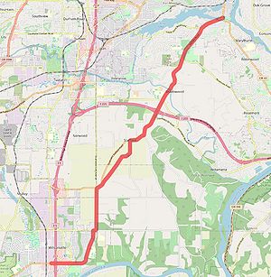
Oregon Route 231 was a secondary state route assigned in 1934 between US-99 in Oswego (now OR-43 in Lake Oswego) and OR-217 in Wilsonville. It was designated along Clackamas County Market Road #12, but it is unknown at this time whether or not the route number was ever posted along the road. Today, the road is known as McVey Avenue in Lake Oswego, SW Stafford Road in Clackamas County, and SW Wilsonville Road in Wilsonville.
History
Clackamas County Market Road #12 was built at some point prior to 1880 and was known colloquially as the "Oswego Road,"[1] "Oswego-Wilsonville Road"[2] and "South Oswego-Wilsonville Road"[3]. It had one major bridge over the Tualatin River, the Shipley Bridge near Wanker's Corner, that was also built prior to 1880; the original bridge was washed away in a massive storm on January 9th of that year[1] and was replaced soon after with a wooden covered bridge[4]. The road was paved in sections, starting north of Shipley Bridge around 1923[2] and completed by 1928[3].
After building a secondary highway system largely from county market roads in 1931 and launching the primary route system in 1932, the Oregon State Highway Department began developing a secondary route system around 1934 to run mostly along secondary highways and some of the remaining market roads. When the list was released, Market Road #12 was assigned OR-231[5]:
Ore. 231 Beginning at a junction with U. S. 99 in Oswego; thence south on Market Road #12 to a junction with Ore. 217 in Wilsonville.
-From "Oregon State Highway Department Designated Route Numbers," c. 1934, p. 3
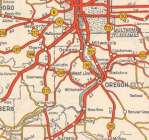
However, when secondary state route numbers started appearing on official state highway maps in 1936, the road between Oswego and Wilsonville did not have a route number associated with it. No official reason for the omission of OR-231 has yet been found, but this will be a topic of future research.
The OR-231 number would later be reused for a stretch of former US-99 in the 1950s and 1960s.
Post OR-231 Assignment
The wooden covered Shipley Bridge would be replaced by a 160-foot steel bridge around 1938-39 at a cost of $47,400, with $21,300 coming from a Public Works Administration grant[6]. Then, in 1958, that bridge was replaced by a 300-foot concrete span[7]. Finally, that bridge was replaced by a 445-foot concrete structure in 2010 at a cost of $9.9 million[8].
It is unclear at this time when the road started becoming referred to more as "Stafford Road".
The intersection of Stafford Road and Borland Road (Market Road #4, OR-244 from 1934 to 1952 and OR-212 from 1952 to 1980) caused long backups in the 2000s. The primary causes were because the intersection was a 4-way stop and because both roads were being used as alternatives to nearby freeways. Clackamas County replaced the 4-way stop with a roundabout opened in the fall of 2009, funded largely by a nearby church; at a cost of $4 million, it was the county's first two-lane roundabout[9].
References
- ↑ 1.0 1.1 The Daily Oregonian. "The Recent Storm," 14 January 1880, p. 1
- ↑ 2.0 2.1 The Sunday Oregonian. "Oswego-Wilsonville Road Paving Is Progressing," 28 October 1923, p. 3
- ↑ 3.0 3.1 The Sunday Oregonian. "Portland-Salem Super-Highways," 4 November 1928, p. 1
- ↑ The Sunday Oregonian. "Bridge Grant Accepted," 12 October 1938, p. 4
- ↑ Oregon State Highway Department. "Designated Route Numbers," c. 1934, p. 3.
- ↑ The Oregonian. "$144,328 Tagged for Oregon Jobs," 30 September 1938, p. 6
- ↑ The Oregonian. "Highway Bids Due Aug. 19," 6 August 1958, p. 10
- ↑ The Oregonian. "Spans Open to Traffic as Bridge Work Progresses," 10 July 2010
- ↑ West Linn Tidings. "Roundabout Takes Shape," 6 August 2008, last accessed 2021 February 4
