Difference between revisions of "Oregon Route 127"
(Added information on construction and transfer approvals) |
(Added Description section) |
||
| (17 intermediate revisions by the same user not shown) | |||
| Line 1: | Line 1: | ||
| − | {{Routebox|type=OR|number=127|name=Oregon Route 127|highway=Cornelius Pass Highway #127|map=OR_127-map.jpg|maintained_by=Oregon Department of Transportation|length= | + | {{Routebox|type=OR|number=127|name=Oregon Route 127|highway=Cornelius Pass Highway #127|map=OR_127-map.jpg|maintained_by=Oregon Department of Transportation|length=7.84|created=2020|start_terminus_dir=North|start_terminus={{Jct|type=US|number=30|page=US Route 30|route=US-30}} near Burlington|end_terminus_dir=South|end_terminus={{Jct|type=US|number=26|page=US Route 26|route=US-26}} in Hillsboro|prev_route={{Jct|type=OR|number=126|page=Oregon Route 126|route=OR-126}}|next_route={{Jct|type=OR|number=130|page=Oregon Route 130|route=OR-130|align=right}}}} |
| − | '''Oregon Route 127''' is a | + | '''Oregon Route 127''' is a state route that runs between [[US Route 30|US-30]] near Burlington and [[US Route 26|US-26]] in Hillsboro along the northern portion of Cornelius Pass Road. It is known internally to the Oregon Department of Transportation as the '''Cornelius Pass Highway #127'''. Originally a Multnomah and Washington County road, jurisdiction was transferred to ODOT on March 1, 2021.<ref name="jt844">Oregon Department of Transportation/Washington County. "Jurisdictional Transfer Agreement #844," 23 November 2020, https://www.oregon.gov/odot/Get-Involved/OTCSupportMaterials/Consent_08_Attach_03_JT_844_Agreement.pdf, last accessed 9 February 2021</ref> As of April 2, 2021, no mileposts have been erected on Washington County's portion. However, as of May 28, 2021, the northern end has both a BEGIN and END OR-127 shield assembly, with the southern end having just an END OR-127 assembly. OR-127 shields also have been posted on both directions of US-30 near the junction with the highway, as well as on the sign blades at the intersection itself. In addition, OR-127 shields can been seen on traffic lights at intersections with cross-streets like NE Wagon Drive as of April 5, 2021. |
| + | |||
| + | Prior to jurisdictional transfer, Cornelius Pass Road was comprised of Multnomah County Roads #891, #891-A and #1642<ref name="jt845">Oregon Department of Transportation/Multnomah County. "Jurisdictional Transfer Agreement #845," 6 November 2020, https://www.oregon.gov/odot/Get-Involved/OTCSupportMaterials/Consent_09_Attach_03_JT_845_Agreement.pdf, last accessed 9 February 2021</ref> and Washington County Roads #2459 and part of #1172.<ref name="jt844" /> In addition, the 2016 Multnomah County Road Log shows it as County Road #172.<ref name="multco_roadlist_2016-12-21">Multnomah County. "PCI by Road Section (A to Z)/ADT," 21 December 2016, p. 4, https://multco.us/file/33797/download, last accessed 8 February 2021</ref> | ||
| + | |||
| + | ==Description== | ||
| + | |||
| + | OR-127's northern terminus is at its junction with US-30 in the unincorporated Multnomah County community of Burlington. From there, it continues southward, roughly paralleling McCarthy Creek as it twists and turns through a narrow canyon full of blind corners and hidden driveways, generally increasing in elevation through Folkenberg, another unincorporated community. About 3 miles from US-30, the road makes a sharp S-curve with a recommended speed of 10 MPH followed by 25 MPH; the road grade also gets steeper as it approaches the summit. At around 3.5 miles, the roadway intersects Skyline Blvd. at the top of Cornelius Pass, roughly 579 feet above sea level.<ref name="usgs_linnton-or_1954">U.S. Geological Survey. ''Linnton Quadrangle, Oregon.'' Map, 7.5 Minute Series. Reston, VA, U.S. Department of the Interior, 1954, last accessed 18 June 2026.</ref> An older alignment of Cornelius Pass Road can be seen branching from Skyline on the right. | ||
| + | |||
| + | After crossing the summit, OR-127 starts to decrease in elevation on a smoother, less serpentine alignment than on the way up, the result of a 1948 realignment. Soon, mountains give way to fields and farmhouses. At roughly 5 miles from the northern terminus, it crosses into Washington County. A quarter mile further south, the road crosses Rock Creek on a bridge, also from 1948; this bridge will be replaced in the summer of 2026.<ref name="washco_cornpass_bridge_about" /> OR-127 then crosses Old Cornelius Pass Road and intersects Germantown Road before crossing West Union Road in the unincorporated community of West Union. | ||
| + | |||
| + | Finally, after crossing into Hillsboro, OR-127 approaches US-26 but technically ends just before it, 7.85 miles from its origin. Cornelius Pass Road continues southward, first as a Sunset Highway connection (#047AW) for about a third of a mile while crossing US-26, then as a county road for another 5 miles along the west side of Hillsboro into the new Reed's Crossing development. After crossing the Butternut Creek Bridge, built between April 2023<ref name="djc-oregon">Dorsey, Hilary. "Bridge construction poised to begin in Hillsboro," DJC Oregon, BridgeTower Media, https://djcoregon.com/news/2022/09/30/bridge-construction-poised-to-begin-in-hillsboro/, 30 September 2022, last accessed 18 June 2026.</ref> and 2024,<ref name="washco_cornpass-south">Washington County. "Cornelius Pass Road Bridge over Butternut Creek," https://www.washingtoncountyor.gov/lut/projects/cornelius-pass-road-bridge-butternut, last accessed 18 June 2026</ref> Cornelius Pass Road ends unceremoniously at Deline Street as of November 2025. Future southward extensions will connect the road to Rosedale Road and [[Oregon Route 10|OR-10/Farmington Road]], though there appear to be no definitive plans for when this will occur. | ||
==History== | ==History== | ||
| Line 6: | Line 16: | ||
===Prior to Jurisdictional Transfer=== | ===Prior to Jurisdictional Transfer=== | ||
| − | Cornelius Pass Road was built at some point in the 19th century by [[Wikipedia:Thomas R. Cornelius|Thomas R. Cornelius]], a prominent Oregon politician and soldier for whom the town of Cornelius is named<ref name="oreg_2008-03-06">Baron, Connie. "Paths Linking Past and Present," ''The Oregonian,'' 6 March 2008, p. 10</ref> | + | ====Through World War II==== |
| + | |||
| + | Cornelius Pass Road was built at some point in the 19th century by [[Wikipedia:Thomas R. Cornelius|Thomas R. Cornelius]], a prominent Oregon politician and soldier for whom the town of Cornelius is named.<ref name="oreg_2008-03-06">Baron, Connie. "Paths Linking Past and Present," ''The Oregonian,'' 6 March 2008, p. 10</ref> The Multnomah County side, a twisting road up the western bank of McCarthy Creek, was mostly widened<ref name="oreg_1931-05-30">''The Morning Oregonian.'' "County Road Jobs Will Be Available," 30 May 1931, p. 12</ref>, paved<ref name="oreg_1931-10-03">''The Morning Oregonian.'' "$569,645 Survives Ax in Road Budget," 3 October 1931, p. 17</ref> and straightened<ref name="oreg_1932-09-04">''The Sunday Oregonian.'' "1933 Road Fund Set at $796,330," 4 September 1932, p. 2</ref> in the early 1930s, with the final half-mile paved in 1936.<ref name="oreg_1936-04-07">''The Morning Oregonian.'' "Paving Favored on Rocky Butte," 7 April 1936, p. 9</ref> At the time, Cornelius Pass Road was described as a "well-surfaced oiled macadam ... road up an easy grade to the summit of the west hills" through "prosperous, well-kept farming country, a bit of woods, and views of the Coast Range."<ref name="oreg_1934-03-18">''The Sunday Oregonian.'' "Let's Go for a Ride," 18 March 1934, sec. 5, p. 1</ref> | ||
| − | The Washington County portion of Cornelius Pass Road was a part of Market Road #22, which ran from Hillsboro through Orenco and West Union to the Multnomah County Line near Rockton. The original alignment ran mostly down the western side of Rock Creek along what is now Old Cornelius Pass Road. | + | The Washington County portion of Cornelius Pass Road was a part of Market Road #22, which ran from Hillsboro through Orenco and West Union to the Multnomah County Line near Rockton and Skyline Blvd. The original alignment south of Skyline ran mostly down the western side of Rock Creek along what is now Old Cornelius Pass Road. This routing is incredibly windy with steep elevation changes and sharp turns. As such, when the Oregon State Highway Commission met with Washington County judges and commissioners on October 11, 1943 to discuss federal funding for post-war highway construction, the court recommended this route to be upgraded.<ref name="oshc_1943-10-11_11746-47">Oregon State Highway Commission minutes, 11 October 1943, p. 11746-47</ref> In April 1945, despite Cornelius Pass Road being a county road, the state highway commission designed a new gentler alignment to the east which included a new bridge over Rock Creek.<ref name="oshd_row_6B-15-4">Oregon State Highway Department. "Drawing No. 6B-15-4: Hillsboro-Cornelius Pass Road, West Union-Cornelius Pass", April 1945.</ref> |
| − | + | ====After World War II==== | |
| − | + | Bids for the project contract were eventually requested on March 25, 1947, with the contract formally awarded to low-bidder Karl F. Jacobsen Co. of Portland on April 7;<ref name="oshd_1949-09-13_fca">Clymer, E. H. and V. R. Jones. "Hillsboro-Cornelius Pass County Road: Final Cost Analysis," 13 September 1949</ref> their bid was $173,325.25 against a cost estimate to $187,162.25.<ref name="oshc_1947-03-25_13789">Oregon State Highway Commission minutes, 25 March 1947, p. 13789</ref><ref name="oshd_1947-04-24_cost">Oregon State Highway Department. "Cost Estimate: West Union-Corenlius Pass Section of the Hillsboro-Cornelius Pass Road in Washington and Multnomah Counties," 24 April 1947</ref> Construction of the bridge was subcontracted out to J. P. Britten at an unknown later date.<ref name="oshd_1949-09-13_fca" /> Construction of the new alignment of Cornelius Pass Road from Germantown Road to Skyline Blvd. began on April 21, 1947, with grading started on July 10.<ref name="oshd_1949-09-13_fca" /> | |
| − | + | The project was due to be completed by October 31, but grading work was halted on September 15 due to unusually heavy rains, not to restart until June 1948.<ref name="oshc_1947-11-25_14355">Oregon State Highway Commission minutes, 25 November 1947, p. 14355</ref><ref name="oshd_1949-09-13_fca" /> In addition to further weather delays, traffic — including "an extremely large amount of log trucks" — was routed along the alignment during construction, causing unexpected damage to the roadway that needed fixing.<ref name="baldock_1949-11-01">Baldock, R. H. letter to the Oregon State Highway Commission, 1 November 1949</ref> The road was officially opened to traffic on September 13, 1948, but additional issues with guardrail paint pushed the project's end date back to April 30, 1949.<ref name="baldock_1948-10-26">Baldock, R. H. letter to T. M. Davis, 26 October 1948</ref><ref name="oshd_1949-09-13_fca" /> On August 8, State Engineer R. H. Baldock sent letters to the Multnomah County Board of Commissioners and the Honorable H. D. Kerkman of the Washington County Court stating that maintenance of Cornelius Pass Road reverted back to county control.<ref name="baldock_1949-08-08_multco">Baldock, R. H. letter to Multnomah County Board of Commissioners, 8 August 1949</ref><ref name="baldock_1949-08-08_washco">Baldock, R. H. letter to Hon. H. D. Kerkman, Washington County Court, 8 August 1949</ref> | |
| + | |||
| + | Ever since the [[Sunset Highway #47]] opened to traffic October 8, 1948,<ref name="washco_1989-03-01">Schmidt, Donna. "The 16-Year Making of the Sunset Highway," ''Times Portrait of Washington County'', 1 & 2 March 1989, p. 10B</ref> Cornelius Pass Road has traveled over it on a bridge. Aerial images from the early 1950s show the highway had a primitive "interchange" with Cornelius Pass Road. This was changed into a trumpet/parclo interchange, likely with the twinning of the Sunset Highway in the mid-1960s. The interchange was rebuilt around 1988-89, and two additional ramps in a half-diamond configuration were opened in 2005.<ref name="oreg_2005-01-10">''The Oregonian.'' "U.S. 26 Work Continues," 10 January 2005, p. B2</ref>. | ||
| + | |||
| + | Starting in 1979, the state once again led the planning of a small construction project on Cornelius Pass Road to realign a dangerous Y-intersection at Germantown Road.<ref name="lowe_1983-07-07">Lowe, T. P. "Final Acceptance Report: Germantown Road @ Cornelius Pass Road," 7 July 1983.</ref> Plans were approved by Washington County on July 6, 1981 and finalized by ODOT by September 1981.<ref name="odot_vfile_15V-288">Oregon Department of Transportation. "As-Built 15V-288: FAS A663 (Germantown Rd.), Germantown Rd. at Cornelius Pass Rd. Sec.", September 1981.</ref> C. G. Gredvig of Portland was formally awarded the contract on September 17 with a bid of $52,442.50.<ref name="oshd_1981-11-05_field">Oregon Department of Transportation. "Field Engineer's Weekly Report: Germantown Rd. Connection," 5 November 1981</ref><ref name="otc_1981-10-22_4333">Oregon Transportation Commission minutes, 22 October 1981, p. 4333</ref> Work started on September 22 and concluded by October 16, more than two weeks early.<ref name="oshd_1981-11-05_field" /> C. T. Keasey, ODOT's Assistant State Highway Engineer, eventually signed off on the contract on January 15, 1982.<ref name="odot-keasey_1982-02-10">Keasey, C. T. "Report of Action Under Delegated Authority by Assistant State Highway Engineer," 10 February 1982</ref> This intersection was further adjusted in 2020, limiting traffic on Germantown Road to eastbound-only between Cornelius Pass Road and Old Cornelius Pass Road.<ref name="washco_cornpass_complete" /> | ||
| + | |||
| + | In the late 1980s, Cornelius Pass Road was suggested as a possible route for a "Westside Bypass" travelling from [[Interstate 5|I-5]] near the junction of [[Interstate 205|I-205]] in Tualatin through the Aloha area and the West Hills into Washington state, though numerous proposals have failed to gain steam due to opposition.<ref name="oreg_1988-11-22">Green, Ashbel S. "State Agency, 1000 Friends Appeal Westside Bypass," ''The Oregonian,'' 22 November 1988, p. B12</ref> | ||
| + | |||
| + | ====In the 21st Century==== | ||
| + | |||
| + | No major realignments have occurred along Cornelius Pass Road between US-26 and US-30 since 1948, and no minor realignments since 1981. However, Multnomah County started focusing their efforts on making safety improvements to their portion, as more than a third of all accidents in western Multnomah County were on this road.<ref name="oreg_2008-04-12">Malkin, Whitney. "Family Hopes to Keep Road from Claiming Another Life," ''The Oregonian,'' 12 April 2008, p. C1</ref> In the wake of the December 2007 death of Taija Belwood, a 17-year-old whose car lost control on an icy patch of the road and landed upside-down in a creek, county officials declared that the entire Multnomah County portion would become a no-passing zone.<ref name="oreg_2008-04-12" /> In January 2010, the county received funding from the American Recovery and Reinvestment Act of 2009 to add rumble strips, vehicle speed readout signs, and a flashing yellow signal; those changes were made over the following months.<ref name="multco_2010-01-18_release">Multnomah County Public Affairs Office. "Work Begins on Cornelius Pass Road Safety Improvements," https://web.archive.org/web/20101231185745/https://web.multco.us/pressrelease/2010/01/18/work-begins-cornelius-pass-road-safety-improvements, archived from [https://web.multco.us/pressrelease/2010/01/18/work-begins-cornelius-pass-road-safety-improvements original] 31 December 2010, last accessed 2 June 2026</ref> | ||
===Jurisdictional Transfer=== | ===Jurisdictional Transfer=== | ||
| Line 20: | Line 42: | ||
In 2015, the Oregon State Legislature passed Senate Bill 117, which set up a task force to identify and recommend candidates for the jurisdictional transfer of highways and roads to and from the state of Oregon<ref name="orleg_2015_sb117">Senate Bill 117, Oregon State Legislature, 2015 Session, https://olis.leg.state.or.us/liz/2015R1/Measures/Overview/SB117, last accessed 8 February 2021</ref>. While many roads were identified for possible transfer from the state to cities and counties, a few county roads were recommended for transfer to ODOT for maintenance. A March 16, 2015 letter from Paul Mather, ODOT Highway Administrator, to the Senate Committee on Business and Transportation included maps showing candidate transfers across the state; the map for the Portland area included Cornelius Pass Road as a possible transfer from county to state maintenance<ref name="letter_matherp_orsenate_2015-03-16">Mather, Paul letter to Oregon Senate Committee on Business and Transportation, 16 March 2015</ref>. | In 2015, the Oregon State Legislature passed Senate Bill 117, which set up a task force to identify and recommend candidates for the jurisdictional transfer of highways and roads to and from the state of Oregon<ref name="orleg_2015_sb117">Senate Bill 117, Oregon State Legislature, 2015 Session, https://olis.leg.state.or.us/liz/2015R1/Measures/Overview/SB117, last accessed 8 February 2021</ref>. While many roads were identified for possible transfer from the state to cities and counties, a few county roads were recommended for transfer to ODOT for maintenance. A March 16, 2015 letter from Paul Mather, ODOT Highway Administrator, to the Senate Committee on Business and Transportation included maps showing candidate transfers across the state; the map for the Portland area included Cornelius Pass Road as a possible transfer from county to state maintenance<ref name="letter_matherp_orsenate_2015-03-16">Mather, Paul letter to Oregon Senate Committee on Business and Transportation, 16 March 2015</ref>. | ||
| − | The | + | The transfer was included as part of House Bill 2017 called "Keep Oregon Moving" which was passed as part of the 2017 legislative session and signed by Gov. Kate Brown<ref name="cornpass_transfer_homepage">Oregon Department of Transportation. "NW Cornelius Pass Road Jurisdictional Transfer," last updated 17 December 2020, https://www.oregon.gov/odot/projects/pages/project-details.aspx?project=CornPassTransfer, last accessed 8 February 2021</ref>. Because the road crosses a county line, two separate jurisdictional transfer agreements had to be created, #844 for Washington County<ref name="jt844" /> and #845 for Multnomah County<ref name="jt845" />, each requiring the county to make safety improvements. Multnomah County realigned some curves (including a sharp S-curve near Skyline Blvd.), widened shoulders, added and replaced mileposts, and installed guardrails on their portion in the summers of 2019 and 2020 at a cost of $5.65 million<ref name="multco_cornpass_info">Multnomah County. "Cornelius Pass Road Safety Improvements," last updated 18 December 2020, https://multco.us/roads/webform/cornelius-pass-road-safety-improvements, last accessed 8 February 2021</ref>. On the Washington County side, the intersection of Cornelius Pass Road, Old Cornelius Pass and Germantown Road was improved, including adding a traffic signal, between October 2019 and May 2020 at a cost of $1.1 million<ref name="washco_cornpass_comment">Washington County. "Comment Online on Intersection Project Through Nov. 8," https://www.washingtoncountyor.gov/lut/news/comment-online-intersection-project-through-nov-8, last accessed 2 June 2026</ref><ref name="washco_cornpass_complete">Washington County. "Cornelius Pass Road/Germantown Road Intersection," https://www.washingtoncountyor.gov/lut/projects/cornelius-pass-germantown-intersection, last accessed 2 June 2026</ref>. |
| + | |||
| + | After the counties completed their construction projects, Washington County approved the transfer on October 12, 2020<ref name="wccc_agenda_packet_2020-10-12">Washington County Coordinating Committee. October 2020 Agenda, 12 October 2020, p. 2, https://www.co.washington.or.us/LUT/Divisions/LongRangePlanning/PlanningPrograms/TransportationPlanning/upload/WCCC-Agenda_Packet4_2020-1012.pdf, last accessed 8 February 2021</ref>, with Multnomah County following suit on December 17, 2020<ref name="mcbc_memo_2020-12-17">Multnomah County Board of Commissioners. "Multnomah County Board approves transfer of Cornelius Pass Road to ODOT," 17 December 2020, https://multco.us/multnomah-county/news/multnomah-county-board-approves-transfer-cornelius-pass-road-odot, last accessed 8 February 2021</ref>. The Oregon Transportation Commission approved the transfers at their meeting on January 21, 2021<ref name="otc_2021-01-21_3133-36">Oregon Transportation Commission agenda, 21 January 2021, p. 3</ref>. ODOT officially took over jurisdiction of Cornelius Pass Road on March 1, 2021, save for the 1946 bridge over Rock Creek in Washington County which will be transferred once the county replaces it<ref name="jt844" /><ref name="washco_cornpass_bridge_about">Washington County. "Cornelius Pass Road Bridge at Rock Creek Replacement," https://www.washingtoncountyor.gov/lut/projects/cornelius-pass-road-bridge-rock-creek, last accessed 2 June 2026</ref>. | ||
| + | |||
| + | <br clear="all" /> | ||
| + | |||
| + | ==Traffic Data== | ||
| + | |||
| + | {{See|article=[[Oregon Route 127 Historical Traffic Data]]}} | ||
| + | |||
| + | The chart below shows the annual average daily traffic (AADT) along OR-127 according to 2023 ODOT data<ref name="odot_2023_tvt">Oregon Department of Transportation. "Traffic Volume Tables for State Highways 2023," https://www.oregon.gov/odot/Data/Documents/TVT_2023.xlsx, 29 August 2024, last accessed 7 May 2025</ref>: | ||
| + | |||
| + | [[File:2023 or-127 aadt.png|||center|2023 Oregon Route 127 AADT Data]] | ||
| + | |||
| + | The milepoints shown above are from the ''highway'', but the data has been ordered by overall ''route'' milepoint. | ||
| + | |||
| + | ==Gallery== | ||
| − | + | <gallery caption="November 14, 2020" widths="180px" heights="120px" class="center"> | |
| + | 2020-11-14-cornpass-road-6281.jpg|Looking south along Cornelius Pass Road, just south of the junction with US-30 | ||
| + | 2020-11-14-cornpass-road-6284.jpg|A close-up of the sign for the project for Multnomah County's improvements to Cornelius Pass Road | ||
| + | 2020-11-14-cornpass-road-6288.jpg|Looking north along Cornelius Pass Road at milepost 3.5, just north of Skyline Blvd. | ||
| + | 2020-11-14-cornpass-road-6312.jpg|At the intersection of Cornelius Pass Road and Skyline Blvd., shields direct traffic to either US-26 or US-30 | ||
| + | </gallery> | ||
==References== | ==References== | ||
<references /> | <references /> | ||
Latest revision as of 01:26, 18 June 2026
 |
|||
| Oregon Route 127 | |||
| Cornelius Pass Highway #127 | |||
 |
|||
| Route Information | |||
|---|---|---|---|
| Maintained by Oregon Department of Transportation | |||
| Length | 7.84 mi. | ||
| Existed | 2020 to present | ||
| Junctions | |||
| North End | |||
| South End | |||
| Navigation | |||
|
|||
Oregon Route 127 is a state route that runs between US-30 near Burlington and US-26 in Hillsboro along the northern portion of Cornelius Pass Road. It is known internally to the Oregon Department of Transportation as the Cornelius Pass Highway #127. Originally a Multnomah and Washington County road, jurisdiction was transferred to ODOT on March 1, 2021.[1] As of April 2, 2021, no mileposts have been erected on Washington County's portion. However, as of May 28, 2021, the northern end has both a BEGIN and END OR-127 shield assembly, with the southern end having just an END OR-127 assembly. OR-127 shields also have been posted on both directions of US-30 near the junction with the highway, as well as on the sign blades at the intersection itself. In addition, OR-127 shields can been seen on traffic lights at intersections with cross-streets like NE Wagon Drive as of April 5, 2021.
Prior to jurisdictional transfer, Cornelius Pass Road was comprised of Multnomah County Roads #891, #891-A and #1642[2] and Washington County Roads #2459 and part of #1172.[1] In addition, the 2016 Multnomah County Road Log shows it as County Road #172.[3]
Contents
Description
OR-127's northern terminus is at its junction with US-30 in the unincorporated Multnomah County community of Burlington. From there, it continues southward, roughly paralleling McCarthy Creek as it twists and turns through a narrow canyon full of blind corners and hidden driveways, generally increasing in elevation through Folkenberg, another unincorporated community. About 3 miles from US-30, the road makes a sharp S-curve with a recommended speed of 10 MPH followed by 25 MPH; the road grade also gets steeper as it approaches the summit. At around 3.5 miles, the roadway intersects Skyline Blvd. at the top of Cornelius Pass, roughly 579 feet above sea level.[4] An older alignment of Cornelius Pass Road can be seen branching from Skyline on the right.
After crossing the summit, OR-127 starts to decrease in elevation on a smoother, less serpentine alignment than on the way up, the result of a 1948 realignment. Soon, mountains give way to fields and farmhouses. At roughly 5 miles from the northern terminus, it crosses into Washington County. A quarter mile further south, the road crosses Rock Creek on a bridge, also from 1948; this bridge will be replaced in the summer of 2026.[5] OR-127 then crosses Old Cornelius Pass Road and intersects Germantown Road before crossing West Union Road in the unincorporated community of West Union.
Finally, after crossing into Hillsboro, OR-127 approaches US-26 but technically ends just before it, 7.85 miles from its origin. Cornelius Pass Road continues southward, first as a Sunset Highway connection (#047AW) for about a third of a mile while crossing US-26, then as a county road for another 5 miles along the west side of Hillsboro into the new Reed's Crossing development. After crossing the Butternut Creek Bridge, built between April 2023[6] and 2024,[7] Cornelius Pass Road ends unceremoniously at Deline Street as of November 2025. Future southward extensions will connect the road to Rosedale Road and OR-10/Farmington Road, though there appear to be no definitive plans for when this will occur.
History
Prior to Jurisdictional Transfer
Through World War II
Cornelius Pass Road was built at some point in the 19th century by Thomas R. Cornelius, a prominent Oregon politician and soldier for whom the town of Cornelius is named.[8] The Multnomah County side, a twisting road up the western bank of McCarthy Creek, was mostly widened[9], paved[10] and straightened[11] in the early 1930s, with the final half-mile paved in 1936.[12] At the time, Cornelius Pass Road was described as a "well-surfaced oiled macadam ... road up an easy grade to the summit of the west hills" through "prosperous, well-kept farming country, a bit of woods, and views of the Coast Range."[13]
The Washington County portion of Cornelius Pass Road was a part of Market Road #22, which ran from Hillsboro through Orenco and West Union to the Multnomah County Line near Rockton and Skyline Blvd. The original alignment south of Skyline ran mostly down the western side of Rock Creek along what is now Old Cornelius Pass Road. This routing is incredibly windy with steep elevation changes and sharp turns. As such, when the Oregon State Highway Commission met with Washington County judges and commissioners on October 11, 1943 to discuss federal funding for post-war highway construction, the court recommended this route to be upgraded.[14] In April 1945, despite Cornelius Pass Road being a county road, the state highway commission designed a new gentler alignment to the east which included a new bridge over Rock Creek.[15]
After World War II
Bids for the project contract were eventually requested on March 25, 1947, with the contract formally awarded to low-bidder Karl F. Jacobsen Co. of Portland on April 7;[16] their bid was $173,325.25 against a cost estimate to $187,162.25.[17][18] Construction of the bridge was subcontracted out to J. P. Britten at an unknown later date.[16] Construction of the new alignment of Cornelius Pass Road from Germantown Road to Skyline Blvd. began on April 21, 1947, with grading started on July 10.[16]
The project was due to be completed by October 31, but grading work was halted on September 15 due to unusually heavy rains, not to restart until June 1948.[19][16] In addition to further weather delays, traffic — including "an extremely large amount of log trucks" — was routed along the alignment during construction, causing unexpected damage to the roadway that needed fixing.[20] The road was officially opened to traffic on September 13, 1948, but additional issues with guardrail paint pushed the project's end date back to April 30, 1949.[21][16] On August 8, State Engineer R. H. Baldock sent letters to the Multnomah County Board of Commissioners and the Honorable H. D. Kerkman of the Washington County Court stating that maintenance of Cornelius Pass Road reverted back to county control.[22][23]
Ever since the Sunset Highway #47 opened to traffic October 8, 1948,[24] Cornelius Pass Road has traveled over it on a bridge. Aerial images from the early 1950s show the highway had a primitive "interchange" with Cornelius Pass Road. This was changed into a trumpet/parclo interchange, likely with the twinning of the Sunset Highway in the mid-1960s. The interchange was rebuilt around 1988-89, and two additional ramps in a half-diamond configuration were opened in 2005.[25].
Starting in 1979, the state once again led the planning of a small construction project on Cornelius Pass Road to realign a dangerous Y-intersection at Germantown Road.[26] Plans were approved by Washington County on July 6, 1981 and finalized by ODOT by September 1981.[27] C. G. Gredvig of Portland was formally awarded the contract on September 17 with a bid of $52,442.50.[28][29] Work started on September 22 and concluded by October 16, more than two weeks early.[28] C. T. Keasey, ODOT's Assistant State Highway Engineer, eventually signed off on the contract on January 15, 1982.[30] This intersection was further adjusted in 2020, limiting traffic on Germantown Road to eastbound-only between Cornelius Pass Road and Old Cornelius Pass Road.[31]
In the late 1980s, Cornelius Pass Road was suggested as a possible route for a "Westside Bypass" travelling from I-5 near the junction of I-205 in Tualatin through the Aloha area and the West Hills into Washington state, though numerous proposals have failed to gain steam due to opposition.[32]
In the 21st Century
No major realignments have occurred along Cornelius Pass Road between US-26 and US-30 since 1948, and no minor realignments since 1981. However, Multnomah County started focusing their efforts on making safety improvements to their portion, as more than a third of all accidents in western Multnomah County were on this road.[33] In the wake of the December 2007 death of Taija Belwood, a 17-year-old whose car lost control on an icy patch of the road and landed upside-down in a creek, county officials declared that the entire Multnomah County portion would become a no-passing zone.[33] In January 2010, the county received funding from the American Recovery and Reinvestment Act of 2009 to add rumble strips, vehicle speed readout signs, and a flashing yellow signal; those changes were made over the following months.[34]
Jurisdictional Transfer
In 2015, the Oregon State Legislature passed Senate Bill 117, which set up a task force to identify and recommend candidates for the jurisdictional transfer of highways and roads to and from the state of Oregon[35]. While many roads were identified for possible transfer from the state to cities and counties, a few county roads were recommended for transfer to ODOT for maintenance. A March 16, 2015 letter from Paul Mather, ODOT Highway Administrator, to the Senate Committee on Business and Transportation included maps showing candidate transfers across the state; the map for the Portland area included Cornelius Pass Road as a possible transfer from county to state maintenance[36].
The transfer was included as part of House Bill 2017 called "Keep Oregon Moving" which was passed as part of the 2017 legislative session and signed by Gov. Kate Brown[37]. Because the road crosses a county line, two separate jurisdictional transfer agreements had to be created, #844 for Washington County[1] and #845 for Multnomah County[2], each requiring the county to make safety improvements. Multnomah County realigned some curves (including a sharp S-curve near Skyline Blvd.), widened shoulders, added and replaced mileposts, and installed guardrails on their portion in the summers of 2019 and 2020 at a cost of $5.65 million[38]. On the Washington County side, the intersection of Cornelius Pass Road, Old Cornelius Pass and Germantown Road was improved, including adding a traffic signal, between October 2019 and May 2020 at a cost of $1.1 million[39][31].
After the counties completed their construction projects, Washington County approved the transfer on October 12, 2020[40], with Multnomah County following suit on December 17, 2020[41]. The Oregon Transportation Commission approved the transfers at their meeting on January 21, 2021[42]. ODOT officially took over jurisdiction of Cornelius Pass Road on March 1, 2021, save for the 1946 bridge over Rock Creek in Washington County which will be transferred once the county replaces it[1][5].
Traffic Data
The chart below shows the annual average daily traffic (AADT) along OR-127 according to 2023 ODOT data[43]:

The milepoints shown above are from the highway, but the data has been ordered by overall route milepoint.
Gallery
- November 14, 2020
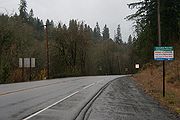
Looking south along Cornelius Pass Road, just south of the junction with US-30
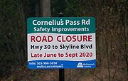
A close-up of the sign for the project for Multnomah County's improvements to Cornelius Pass Road

Looking north along Cornelius Pass Road at milepost 3.5, just north of Skyline Blvd.
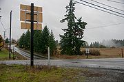
At the intersection of Cornelius Pass Road and Skyline Blvd., shields direct traffic to either US-26 or US-30


References
- ↑ 1.0 1.1 1.2 1.3 Oregon Department of Transportation/Washington County. "Jurisdictional Transfer Agreement #844," 23 November 2020, https://www.oregon.gov/odot/Get-Involved/OTCSupportMaterials/Consent_08_Attach_03_JT_844_Agreement.pdf, last accessed 9 February 2021
- ↑ 2.0 2.1 Oregon Department of Transportation/Multnomah County. "Jurisdictional Transfer Agreement #845," 6 November 2020, https://www.oregon.gov/odot/Get-Involved/OTCSupportMaterials/Consent_09_Attach_03_JT_845_Agreement.pdf, last accessed 9 February 2021
- ↑ Multnomah County. "PCI by Road Section (A to Z)/ADT," 21 December 2016, p. 4, https://multco.us/file/33797/download, last accessed 8 February 2021
- ↑ U.S. Geological Survey. Linnton Quadrangle, Oregon. Map, 7.5 Minute Series. Reston, VA, U.S. Department of the Interior, 1954, last accessed 18 June 2026.
- ↑ 5.0 5.1 Washington County. "Cornelius Pass Road Bridge at Rock Creek Replacement," https://www.washingtoncountyor.gov/lut/projects/cornelius-pass-road-bridge-rock-creek, last accessed 2 June 2026
- ↑ Dorsey, Hilary. "Bridge construction poised to begin in Hillsboro," DJC Oregon, BridgeTower Media, https://djcoregon.com/news/2022/09/30/bridge-construction-poised-to-begin-in-hillsboro/, 30 September 2022, last accessed 18 June 2026.
- ↑ Washington County. "Cornelius Pass Road Bridge over Butternut Creek," https://www.washingtoncountyor.gov/lut/projects/cornelius-pass-road-bridge-butternut, last accessed 18 June 2026
- ↑ Baron, Connie. "Paths Linking Past and Present," The Oregonian, 6 March 2008, p. 10
- ↑ The Morning Oregonian. "County Road Jobs Will Be Available," 30 May 1931, p. 12
- ↑ The Morning Oregonian. "$569,645 Survives Ax in Road Budget," 3 October 1931, p. 17
- ↑ The Sunday Oregonian. "1933 Road Fund Set at $796,330," 4 September 1932, p. 2
- ↑ The Morning Oregonian. "Paving Favored on Rocky Butte," 7 April 1936, p. 9
- ↑ The Sunday Oregonian. "Let's Go for a Ride," 18 March 1934, sec. 5, p. 1
- ↑ Oregon State Highway Commission minutes, 11 October 1943, p. 11746-47
- ↑ Oregon State Highway Department. "Drawing No. 6B-15-4: Hillsboro-Cornelius Pass Road, West Union-Cornelius Pass", April 1945.
- ↑ 16.0 16.1 16.2 16.3 16.4 Clymer, E. H. and V. R. Jones. "Hillsboro-Cornelius Pass County Road: Final Cost Analysis," 13 September 1949
- ↑ Oregon State Highway Commission minutes, 25 March 1947, p. 13789
- ↑ Oregon State Highway Department. "Cost Estimate: West Union-Corenlius Pass Section of the Hillsboro-Cornelius Pass Road in Washington and Multnomah Counties," 24 April 1947
- ↑ Oregon State Highway Commission minutes, 25 November 1947, p. 14355
- ↑ Baldock, R. H. letter to the Oregon State Highway Commission, 1 November 1949
- ↑ Baldock, R. H. letter to T. M. Davis, 26 October 1948
- ↑ Baldock, R. H. letter to Multnomah County Board of Commissioners, 8 August 1949
- ↑ Baldock, R. H. letter to Hon. H. D. Kerkman, Washington County Court, 8 August 1949
- ↑ Schmidt, Donna. "The 16-Year Making of the Sunset Highway," Times Portrait of Washington County, 1 & 2 March 1989, p. 10B
- ↑ The Oregonian. "U.S. 26 Work Continues," 10 January 2005, p. B2
- ↑ Lowe, T. P. "Final Acceptance Report: Germantown Road @ Cornelius Pass Road," 7 July 1983.
- ↑ Oregon Department of Transportation. "As-Built 15V-288: FAS A663 (Germantown Rd.), Germantown Rd. at Cornelius Pass Rd. Sec.", September 1981.
- ↑ 28.0 28.1 Oregon Department of Transportation. "Field Engineer's Weekly Report: Germantown Rd. Connection," 5 November 1981
- ↑ Oregon Transportation Commission minutes, 22 October 1981, p. 4333
- ↑ Keasey, C. T. "Report of Action Under Delegated Authority by Assistant State Highway Engineer," 10 February 1982
- ↑ 31.0 31.1 Washington County. "Cornelius Pass Road/Germantown Road Intersection," https://www.washingtoncountyor.gov/lut/projects/cornelius-pass-germantown-intersection, last accessed 2 June 2026
- ↑ Green, Ashbel S. "State Agency, 1000 Friends Appeal Westside Bypass," The Oregonian, 22 November 1988, p. B12
- ↑ 33.0 33.1 Malkin, Whitney. "Family Hopes to Keep Road from Claiming Another Life," The Oregonian, 12 April 2008, p. C1
- ↑ Multnomah County Public Affairs Office. "Work Begins on Cornelius Pass Road Safety Improvements," https://web.archive.org/web/20101231185745/https://web.multco.us/pressrelease/2010/01/18/work-begins-cornelius-pass-road-safety-improvements, archived from original 31 December 2010, last accessed 2 June 2026
- ↑ Senate Bill 117, Oregon State Legislature, 2015 Session, https://olis.leg.state.or.us/liz/2015R1/Measures/Overview/SB117, last accessed 8 February 2021
- ↑ Mather, Paul letter to Oregon Senate Committee on Business and Transportation, 16 March 2015
- ↑ Oregon Department of Transportation. "NW Cornelius Pass Road Jurisdictional Transfer," last updated 17 December 2020, https://www.oregon.gov/odot/projects/pages/project-details.aspx?project=CornPassTransfer, last accessed 8 February 2021
- ↑ Multnomah County. "Cornelius Pass Road Safety Improvements," last updated 18 December 2020, https://multco.us/roads/webform/cornelius-pass-road-safety-improvements, last accessed 8 February 2021
- ↑ Washington County. "Comment Online on Intersection Project Through Nov. 8," https://www.washingtoncountyor.gov/lut/news/comment-online-intersection-project-through-nov-8, last accessed 2 June 2026
- ↑ Washington County Coordinating Committee. October 2020 Agenda, 12 October 2020, p. 2, https://www.co.washington.or.us/LUT/Divisions/LongRangePlanning/PlanningPrograms/TransportationPlanning/upload/WCCC-Agenda_Packet4_2020-1012.pdf, last accessed 8 February 2021
- ↑ Multnomah County Board of Commissioners. "Multnomah County Board approves transfer of Cornelius Pass Road to ODOT," 17 December 2020, https://multco.us/multnomah-county/news/multnomah-county-board-approves-transfer-cornelius-pass-road-odot, last accessed 8 February 2021
- ↑ Oregon Transportation Commission agenda, 21 January 2021, p. 3
- ↑ Oregon Department of Transportation. "Traffic Volume Tables for State Highways 2023," https://www.oregon.gov/odot/Data/Documents/TVT_2023.xlsx, 29 August 2024, last accessed 7 May 2025