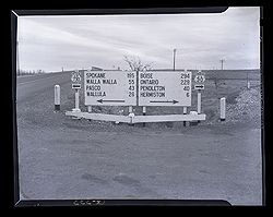
US Route 730
US Route 730 is a US route that runs between Boardman Junction and the Washington state line near Point Kelley, comprising of the easternmost portion of the Columbia River Highway #2. The highway continues into Washington, ending at US Route 12 at Wallula Junction. The total length of US-730 is 41.78 miles long, of which 35.7 miles is in Oregon, making it currently the shortest US route in the country. Originally proposed as US Route 420 in 1925 by AASHO, it was designated as its current number on November 11, 1926 along with the rest of the US route system; however, the underlying road wasn't fully constructed until the mid-1930s.
In addition to being the shortest US route in the system, it's also the highest-numbered US route in the system, as well as Oregon's highest-numbered highway of any type.
History
Pre-Highway History
While native tribes may have traversed the area, there appears to be no known historic pioneer trail crossing the Oregon-Washington border along US-730's present routing. However, Merriwether Lewis and William Clark paralleled the routing on their exploration of the Louisiana Purchase and Pacific Northwest between 1804 and 1806, though by canoeing down the Columbia and returning on horseback on its northern shore. It was located in close proximity to the Oregon Trail of the 1840s, albeit bypassed to the south. An 1863 map of trails and military roads the region does not show any trails in the area of Umatilla County, labeling Oregon's side as "monumental rock"[1].
As it was considered "an obstacle to overcome" due to the terrain and harshness of the environment, few migrants if any settled in the Umatilla area[2]. However, a gold rush in Idaho in Montana in 1862 led to many would-be miners back through what is now Umatilla County, created from a chunk of Wasco County on September 27 that same year; Umatilla City (now Umatilla) was platted in 1863 and incorporated on October 24, 1864[3]. Umatilla City, as it was largely called then, was situated just below the Umatilla Rapids on the Columbia, which prevented boats from progressing further.
References
- ↑ "Map of Military Road from Fort Walla Walla on the Columbia to Fort Benson on the Missouri." United States Department of War via the University of Washington Libraries Map Collection, 1863. Accessed 31 January 2024.
- ↑ Miller, Gary Kenneth (Portland State University). "A History of Transportation in Nineteenth Century Umatilla, Oregon." Dissertations and Theses, Paper 5159, 26 April 1996. Accessed 31 January 2024.
- ↑ "Incorporated Cities: Umatilla". State of Oregon Blue Book, accessed 2 February 2024.

