User contributions
Jump to navigation
Jump to search
- 10:10, 8 May 2021 diff hist +185 N File:2016-02-20 portland-p2-post 1065.jpg
- 07:57, 8 May 2021 diff hist +195 File:Undated - OSHD 181 - John Day Highway With Fossil Mountain Mile Post 116 (Wheeler County).jpg Added metadata (source, ID)
- 07:50, 8 May 2021 diff hist +128 N File:Undated - OSHD 181 - John Day Highway With Fossil Mountain Mile Post 116 (Wheeler County).jpg
- 11:50, 17 April 2021 diff hist +2,210 Oregon Route 2 Additional information on the three proposed short roads to the sea
- 13:26, 14 April 2021 diff hist +4,687 Oregon Route 2 Added information about selecting the original short route, 1930-31
- 00:28, 13 April 2021 diff hist +4 File:2020-05-09 ridge-route-8548.jpg Added link to photographer credit current
- 00:25, 13 April 2021 diff hist +151 N File:2020-05-09 ridge-route-8548.jpg Storey Burn Road looking west towards Larch Mountain and Blue Lake, Tillamook County.<br /> 📷 Jonathan Ledbetter<br /> 📆 9 May 2020
- 16:09, 7 April 2021 diff hist 0 m MediaWiki:Sidebar Uncapitalized "a" in "abbreviations"
- 16:09, 7 April 2021 diff hist +213 N MediaWiki:Sidebar Added common abbreviations link to sidebar
- 13:00, 7 April 2021 diff hist +20 m Common Abbreviations Fixed bold text
- 12:59, 7 April 2021 diff hist +804 N Common Abbreviations Initial commit of Common Abbreviations page
- 11:50, 6 April 2021 diff hist +137 Oregon Route 127 OR-127 shields have started appearing at intersections with Cornelius Pass Road
- 00:41, 5 April 2021 diff hist +191 Oregon Route 6 Additional information on Wilson River Toll Road current
- 13:51, 3 April 2021 diff hist +122 Oregon Route 127 Updated status of route shields along and near highway; cleaned up grammar and sentence structure
- 13:09, 1 April 2021 diff hist +111 Oregon Route 6 Added 1901 wagon road company incorporaion
- 00:47, 1 April 2021 diff hist +194 Oregon Route 6 More information about early Wilson River Road
- 17:50, 27 March 2021 diff hist +164 Oregon Route 127 Shields are still not posted along the highway
- 16:15, 24 March 2021 diff hist +452 N Oregon Route 6 Initial creation of OR-6 page
- 16:23, 18 March 2021 diff hist -15 m Oregon Route 2 Rearranged wording
- 13:02, 18 March 2021 diff hist +2,030 Oregon Route 2
- 21:28, 11 March 2021 diff hist +39 MediaWiki:Common.css Added margins and padding
- 21:24, 11 March 2021 diff hist -4 m Template:UnderConstruction Removed extraneous word current
- 20:43, 11 March 2021 diff hist -3 Template:UnderConstruction Changed message
- 20:37, 11 March 2021 diff hist +202 N Template:Stub Created "stub" template current
- 20:30, 11 March 2021 diff hist +15 Template:UnderConstruction Added banner message class
- 20:30, 11 March 2021 diff hist -8 MediaWiki:Common.css Converted under construction class to banner message class
- 20:21, 11 March 2021 diff hist -17 Oregon Route 2 Added under construction template
- 20:21, 11 March 2021 diff hist -5 Template:UnderConstruction Adjusted how image was aligned
- 20:19, 11 March 2021 diff hist +113 MediaWiki:Common.css Added under construction styles
- 20:15, 11 March 2021 diff hist +6 Template:UnderConstruction Removed link from image
- 20:13, 11 March 2021 diff hist +30 Template:UnderConstruction Added clear all
- 20:11, 11 March 2021 diff hist +182 N Template:UnderConstruction Created "under construction" template
- 20:08, 11 March 2021 diff hist 0 File:Under construction.gif Jonathan uploaded a new version of File:Under construction.gif current
- 20:03, 11 March 2021 diff hist +32 N File:Under construction.gif Under construction
- 09:53, 11 March 2021 diff hist +12,294 N Oregon Route 2 Initial creation of OR-2 page (pre-history only)
- 02:09, 10 March 2021 diff hist +12 File:Multco-image-2.jpg Added line breaks current
- 02:09, 10 March 2021 diff hist +227 N File:Multco-image-2.jpg A bus heading eastbound on the newly-paved Canyon Road entering Portland. 📆 1930 🖼 Multnomah County Archives via [https://vintageportland.wordpress.com/2015/03/04/vista-avenue-viaduct-1930/ Vintage Portland]
- 12:53, 3 March 2021 diff hist +63 Oregon Route 127 ODOT now has jurisdiction over the highway
- 17:25, 24 February 2021 diff hist +57 N File:US 99E 1948.png 1948 version of the route shield for US-99E current
- 17:14, 24 February 2021 diff hist +53 N File:US 99W 1948.png 1948 version of route shield for US-99W current
- 23:33, 15 February 2021 diff hist +58 File:OR 2-map.jpg Added explanation about green lines on map current
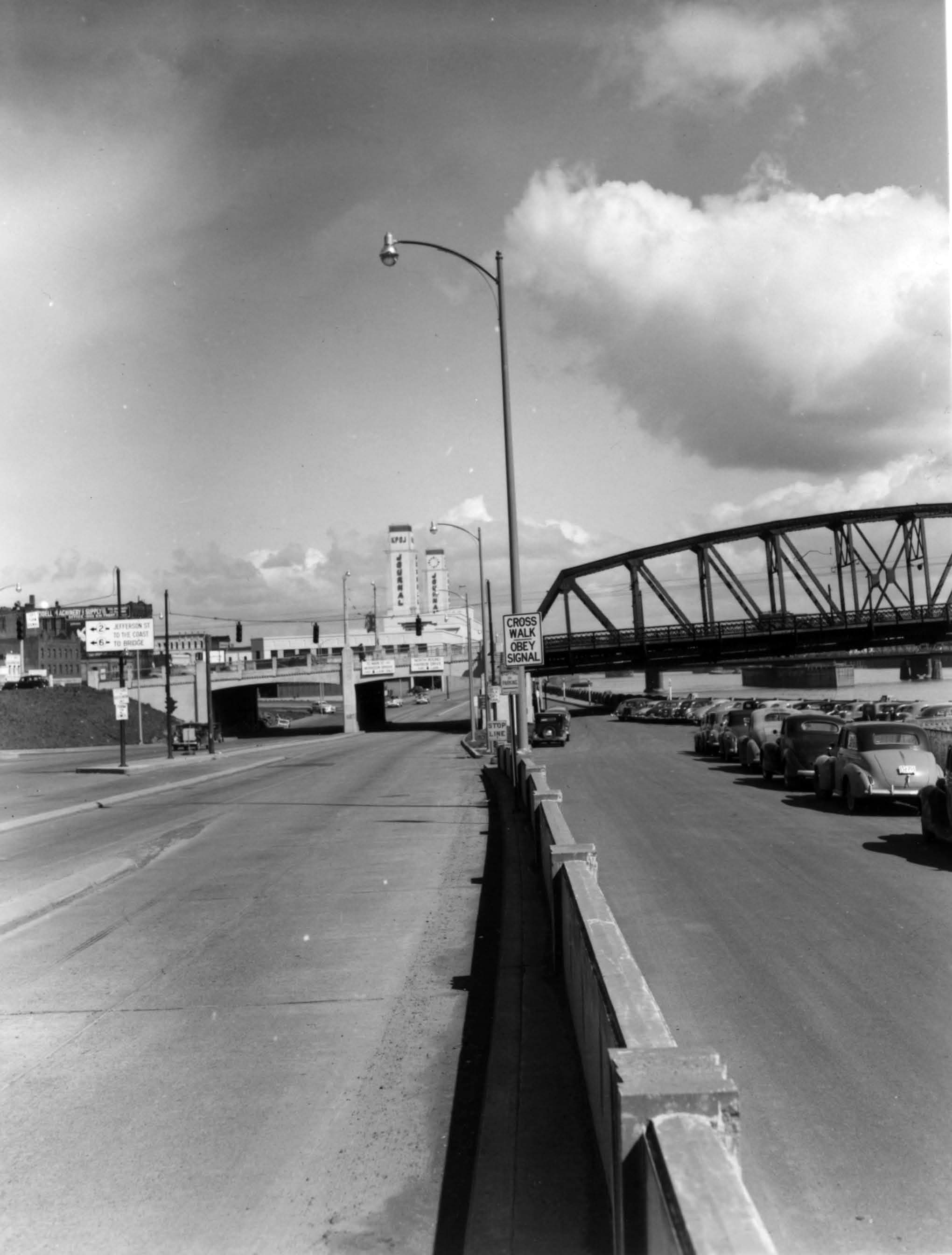
- 01:35, 15 February 2021 diff hist +320 N File:Harbor-dr-south-of-hawthorne-bridge-looking-north-1949-sign.jpg A close-up of the sign in this photo of SW Harbor Drive & Jefferson in Portland.<br /> 📆 1949<br /> 🖼 City of Portland Archives via [https://vintageportland.wordpress.com/2011/04/14/harbor-drive-sw-jefferson-1949/ Vintage Portland] current
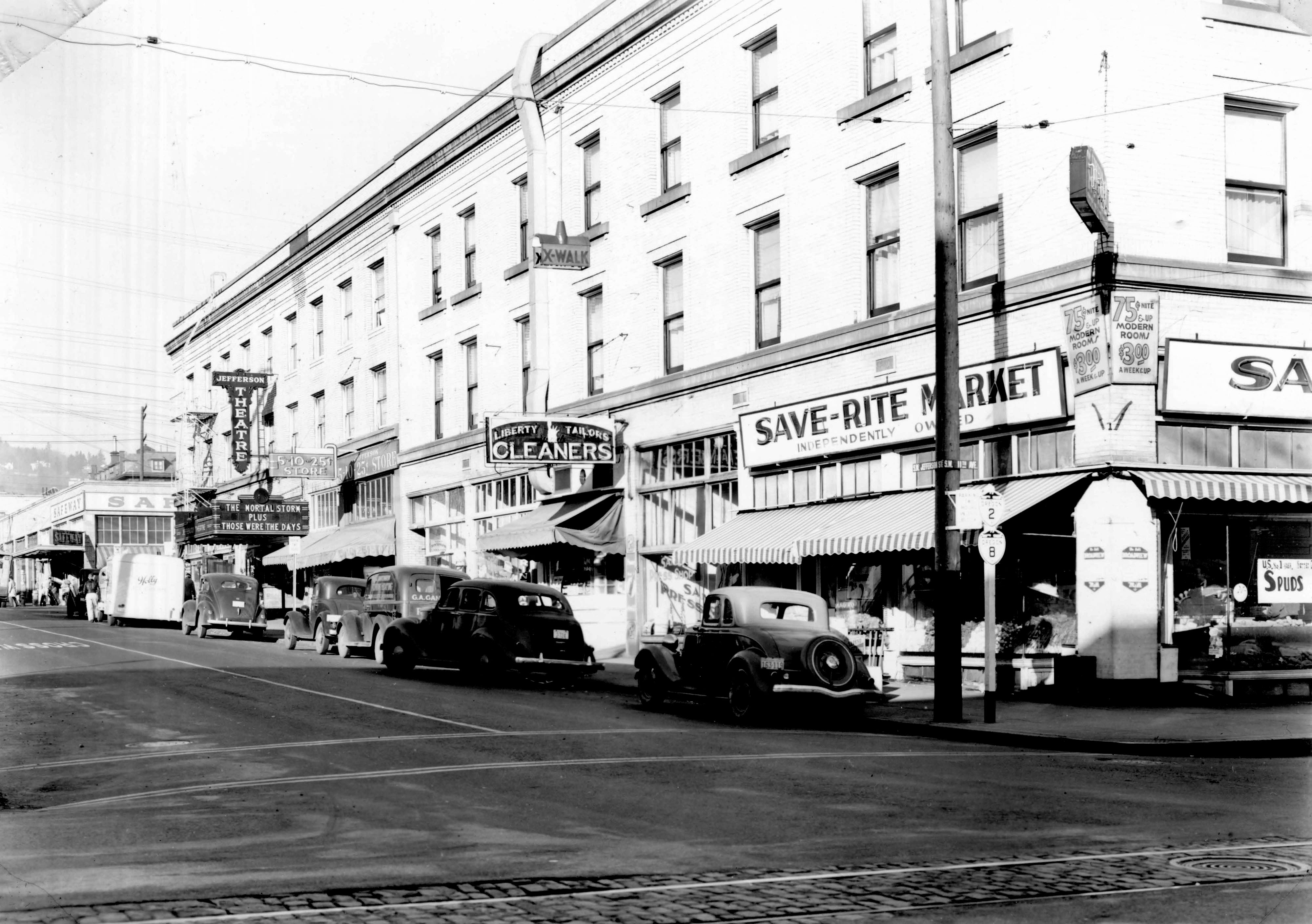
- 01:29, 15 February 2021 diff hist +332 N File:A2005-001-796-sw-jefferson-west-from-11th-1940-shields.jpg A close-up of the shields in this photo of SW Jefferson & 11th in Portland.<br /> 📆 1940<br /> 🖼 City of Portland Archives via [https://vintageportland.wordpress.com/2011/04/25/jefferson-west-apartments-1940/ Vintage Portland]<br /> 🆔 A2005-001.796 current
- 01:25, 15 February 2021 diff hist +255 N File:1942c - OSHD - Cannon Beach Jct with 101 Night Route.jpg A photo of the signs at Cannon Beach Junction, the junction of OR-2 and US-101. A recommended 101 night route sign indicates how motorists can avoid the World War II dim-out zone.<br /> 📆 c. 1942<br /> 🖼 Oregon State Highway Department current
- 22:36, 14 February 2021 diff hist +254 N File:1944 - Gerald W. Williams Collection 207 - Quartz Creek Bridge, Clatsop County, Oregon.jpg The completed Quartz Creek Bridge along the Wolf Creek Highway after a fire.<br /> 📆 1944<br /> 🖼 [https://www.flickr.com/photos/osucommons/8113540767/ OSU Special Collections & Archives] - Gerald W. Williams Collection<br /> 🆔 207 current
- 21:57, 14 February 2021 diff hist +131 N File:Undated - OSHD HPL 31 - Wolf Creek Hwy.jpg Clearing trees and grading along the Wolf Creek Highway.<br /> 🖼 Oregon State Highway Department<br /> 🆔 HPL 31 current
- 21:49, 14 February 2021 diff hist +181 N File:Undated - OSHD HPL 22 - Wolf Creek Hwy @ North Fork Ranger Station Summit.jpg Cutting through the mountain along the North Fork-Ranger Station Summit section of the Wolf Creek Highway.<br /> 🖼 Oregon State Highway Department<br /> 🆔 HPL 22 current
- 19:30, 14 February 2021 diff hist +223 N File:Undated - OSHD G-513 - Wolf Creek showing close up of shovel on cut.jpg Close-up shot of shovel on cut along Wolf Creek Highway.<br /> 🖼 Oregon State Highway Department via [http://records.sos.state.or.us/ORSOSWebDrawer/RecordHtml/6398266 Oregon State Archives]<br /> 🆔 G-513 current
- 19:16, 14 February 2021 diff hist +219 N File:Undated - OSHD G-512 - Wolf Creek showing long shot of shovel on cut.jpg Long shot of shovel on cut along Wolf Creek Highway.<br /> 🖼 Oregon State Highway Department via [http://records.sos.state.or.us/ORSOSWebDrawer/RecordHtml/6398265 Oregon State Archives]<br /> 🆔 G-512 current
- 18:38, 14 February 2021 diff hist +271 N File:Undated - OSHD G-510 - Wolf Creek construction showing Quartz Creek Bridge from below.jpg Construction of the Quartz Creek Bridge on the Wolf Creek Highway as seen from below.<br /> 📆 c. 1938<br /> 🖼 Oregon State Highway Department via [http://records.sos.state.or.us/ORSOSWebDrawer/RecordHtml/6398263 Oregon State Archives]<br /> 🆔 G-510 current
.jpg&oldid=254)
.jpg&diff=prev&oldid=254)
.jpg&action=history)
.jpg)
.jpg&oldid=253)