File:1972-10-13 OSHD AASHO-US395-app p6 part.jpg
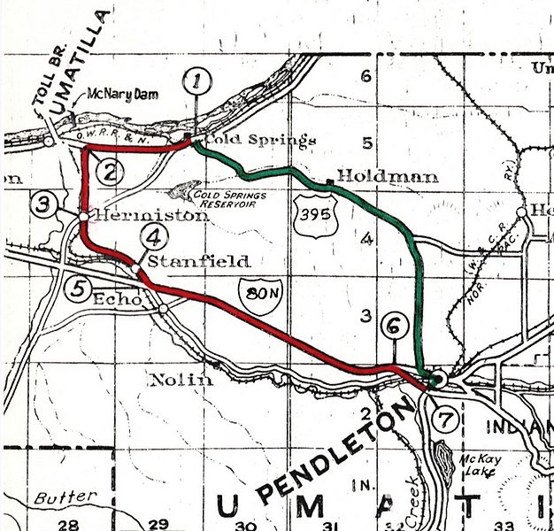
Revision as of 14:16, 28 September 2022 by Jonathan (talk | contribs) (A snippet of the map used on page 6 of the OSHD's 1972 application to AASHO regarding the realignment of US-395. These changes also eliminated OR-32 and created OR-37. Control points referenced on the map:<br /> (1) Cold Springs<br /> (2) Hermiston Jct. - Leaves US730<br /> (3) Hermiston<br /> (4) Stanfield<br /> (5) Stanfield Jct. - Joins I-80N & US30<br /> (6) West Pendleton - Leaves...)

Size of this preview: 626 × 600 pixels. Other resolutions: 251 × 240 pixels | 1,467 × 1,405 pixels.
Original file (1,467 × 1,405 pixels, file size: 761 KB, MIME type: image/jpeg)
Summary
A snippet of the map used on page 6 of the OSHD's 1972 application to AASHO regarding the realignment of US-395. These changes also eliminated OR-32 and created OR-37.
Control points referenced on the map:
(1) Cold Springs
(2) Hermiston Jct. - Leaves US730
(3) Hermiston
(4) Stanfield
(5) Stanfield Jct. - Joins I-80N & US30
(6) West Pendleton - Leaves US30
(7) Pendleton - Leaves I-80N
📆 13 October 1972
📄 Oregon State Highway Department
File history
Click on a date/time to view the file as it appeared at that time.
| Date/Time | Thumbnail | Dimensions | User | Comment | |
|---|---|---|---|---|---|
| current | 14:16, 28 September 2022 |  | 1,467 × 1,405 (761 KB) | Jonathan (talk | contribs) | A snippet of the map used on page 6 of the OSHD's 1972 application to AASHO regarding the realignment of US-395. These changes also eliminated OR-32 and created OR-37. Control points referenced on the map:<br /> (1) Cold Springs<br /> (2) Hermiston Jct. - Leaves US730<br /> (3) Hermiston<br /> (4) Stanfield<br /> (5) Stanfield Jct. - Joins I-80N & US30<br /> (6) West Pendleton - Leaves... |
- You cannot overwrite this file.
File usage
There are no pages that use this file.