Pioneer Highway
The Pioneer Highway — also known by a couple other names — refers to a plan first proposed in 1927 to route a north-south highway between Portland and Salem via the historic townsite of Champoeg. In the mid-1930s, this plan eventually evolved into an east-west highway between US-99W in Newberg and US-99E in Aurora via Champoeg, called the Champoeg Memorial Highway with its own alternative names. While a survey of a 7.13-mile section was completed in February 1936, any plans for a highway through the townsite were ultimately dropped due to issues acquiring right-of-way, burdensome funding regulations, and in-fighting between competing groups that wished to shape the future of what would become the Champoeg State Heritage Area. To this day, there is no state highway that passes by or through Champoeg.
Contents
Routing
North-South Alignment
Very little is known about the exact routing of the north-south highway between Salem and Champoeg, but a couple of different rough routings were proposed north to Portland. When first suggested to the Oregon State Highway Commission in 1927, the highway would have crossed the Willamette River on a bridge at Butteville, a couple miles east of Champoeg, but no defined routing to Portland was mentioned[1]. In 1929, the highway (now referred to as the "Pioneer Highway") was further suggested to the commission that this highway could be routed "via the proposed Tualatin Tunnel" through the West Hills[2]; this tunnel was 1¼ miles long and would have connected what is now OR-10 to the Marquam Gulch area near downtown Portland[3]. By 1931, it was suggested that the Pioneer Highway be 100 feet wide and utilize two arterial highways, one for passenger vehicles and the other for trucks[4].
In 1932, the commission received a petition that defined the routing as "Salem to Champoeg, thence to Butteville, thence crossing the Willamette River to Clackamas County Market Road No. 6 [modern-day Wilsonville Road], thence to Grahams Ferry Road, thence to Tualatin, thence to Portland via Boones Ferry Road"[5]. It is not known whether this alignment ends at Terwilliger Blvd. or at Macadam Ave. by way of Taylors Ferry Road.
East-West Alignment
According to an OSHD Right of Way Map from February 1936[6], the western terminus of the Champoeg Memorial Highway would have been slightly to the south of the Pioneer Memorial Building in the Champoeg State Heritage Area. From there, it would have roughly paralleled the Willamette River easterly along its southern bank, cutting through the original platted streets of Champoeg in the process. At the historic town of Butteville, about 3 miles from the western terminus, the highway would have stopped following the river and curved to meet present-day Arndt Road east of town. From there, it would run due east along Arndt Road, crossing the Oregon Electric Railroad tracks at Butteville Station and eventually straddling the Marion-Clackamas County line. Finally, after a 6.89-mile journey, the Champoeg Memorial Highway would have split into a pair of 0.24-mile wyes to connect to both directions of a slightly-reconstructed Beaverton-Aurora Highway (marked "Tigard-Aurora Highway" on the ROW map) at its eastern terminus. Today, this location is about 2 miles north of Aurora at the corner of Arndt Road and Airport Road, at the northeast corner of the Aurora State Airport.
In addition to Arndt Road, this highway would have run over portions of present-day Schuler Road near Butteville, as well as parts of the Townsite Trail and Champoeg-Butteville Bike Path in and around Champoeg State Heritage Site.
- Close-Ups of February 1936 Champoeg Memorial Highway ROW Map
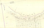
Western terminus, Champoeg State Heritage Area

Butteville
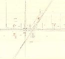
Butteville Station
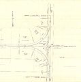
Eastern terminus, Beaverton-Aurora Highway near Aurora


Alternative Names
The Champoeg Memorial Highway was also referred to by these names in various articles, books, correspondence and public meetings:
- Pioneer Highway[2]
- Oregon Pioneer Highway[7]
- Butteville-Champoeg Highway[8]
- Butteville-Champoeg Memorial Highway[9]
History
Champoeg Townsite
Situated on the southern bank of the Willamette River, the former townsite of Champoeg was best known for the Champoeg Meetings between European-American and French-Canadian settlers from 1841 to 1843. After the United States Congress failed to establish a government, these meetings led to a series of votes on May 2, 1843 on whether to form their own provisional government. At the time, control of the territory was disputed between the United States and the United Kingdom, and the British Hudson's Bay Company (HBC) had a sizeable influence in the region. The HBC initially convinced all the French-Canadians to vote against the provisional government twice. During the third vote, two French-Canadians switched their votes to side with the European-Americans, thus establishing a provisional government, 52 to 50. While it was originally hoped that Champoeg would become the capital of this new government, Oregon City ended up being selected instead when the Oregon Territory was formed in 1848.
While the town continued to exist and grow after its failed bid to become the capital, disaster would soon strike. Due to exceedingly heavy rains in November 1861, the town was flooded and mostly washed away on December 2. It was never rebuilt.
Champoeg Park
On June 15, 1901, the Oregon Secretary of State was deeded 1 square rod (or 30¼ square yards) of land at the Champoeg townsite[10]. A monument, dedicated to the 52 settlers who voted to create the provisional government in 1843, was placed upon the land, which became known as Provisional Government Park by 1906[10][11]. In 1913[12] (some sources say 1912[13]), jurisdiction of the park was turned over to the newly-created Board of Control, whose purpose was to "coordinate the management of state institutions, construction of state buildings, and other duties assigned by the legislature"[14]. This was likely done because Oregon did not have a government body dedicated to administering state-owned park lands at the time.
This was rectified on February 28, 1921, when the state legislature allowed the Oregon State Highway Commission to purchase land along state highways for beautification and scenic preservation purposes[15]. This authority was bolstered in 1925, when the commission was specifically allowed to purchase and maintain "parks, parking places, camp sites, public squares and recreation grounds," whether along a highway or not[16]. Despite the commission's new department dedicated to park lands, Provisional Government Park was still administered by the Board of Control at the time, and would be for the foreseeable future.
Pioneer Highway
The park's non-standard jurisdiction appears to have led to some confusion.
References
- ↑ Oregon State Highway Commission minutes, 30 August 1927, p. 2208
- ↑ 2.0 2.1 Oregon State Highway Commission minutes, 26 September 1929, pp. 2569-70
- ↑ Oregon State Highway Commission minutes, 9 September 1930, p. 2794
- ↑ Oregon State Highway Commission minutes, 30 July 1931, p. 3033
- ↑ Oregon State Highway Commission minutes, 5 February 1932, p. 3225
- ↑ Oregon State Highway Department. "Drawing No. 5B-2-14: Champoeg Memorial Highway, Located Line, Champoeg-Wilsonville Section", February 1936
- ↑ "News and Comment", Oregon Historical Quarterly Vol. 34 No. 4, December 1933, p. 379
- ↑ Miller, Milton letter to Governor Charles Martin, 29 October 1936
- ↑ Hussey, J.A. Champoeg: Place of Transition, Portland: Oregon Historical Society, 1967, p. 289
- ↑ 10.0 10.1 Oregon State Parks Department. History of the Oregon State Parks, 1 July 1965, p. 108
- ↑ The Morning Oregonian. "Celebrates at Champoeg," 2 May 1906, p. 10
- ↑ Aurand, Marin and Marc Carpenter. "So the Future Will Have a Place": The First Century of Oregon State Parks, Oregon Parks and Recreation Department, 2022, p. 10
- ↑ History of the Oregon State Parks, p. 109
- ↑ Halvorson, Gary D. "Oregon State Board of Control Agency History," Oregon State Archives, 2003, last accessed 7 August 2025
- ↑ Aurand, p. 15
- ↑ Aurand, p. 16