Difference between revisions of "List of Surviving Concrete Mileposts"
Jump to navigation
Jump to search
(Added MP 178 and added discovery date and person for MPs 79 and 80) |
|||
| (7 intermediate revisions by the same user not shown) | |||
| Line 10: | Line 10: | ||
|- | |- | ||
| style="text-align: center;" | MP 146 || Cottage Grove Museum<br />''Original location north of Willamette River Bridge south of Cottage Grove'' || style="text-align: center;" | Fair || As of 2011<ref name="2011_atcherman">Atcherman, Gail. Email to Laura Wilt, 14 July 2011</ref> || style="text-align: center;" | — | | style="text-align: center;" | MP 146 || Cottage Grove Museum<br />''Original location north of Willamette River Bridge south of Cottage Grove'' || style="text-align: center;" | Fair || As of 2011<ref name="2011_atcherman">Atcherman, Gail. Email to Laura Wilt, 14 July 2011</ref> || style="text-align: center;" | — | ||
| + | |- | ||
| + | | style="text-align: center;" | MP 225|| Bills Rd. south of Tri-City || style="text-align: center;" | Good || Rediscovered in 2024 by Kirk J. Poole and Rick Cornish; further research is needed || style="text-align: center;" | [[File:2024-01-10_pacific_orig-stone-milepost-225_k-poole.jpg|150px|frameless]]<br />(2024) | ||
|- | |- | ||
| style="text-align: center;" | MP 268 || [https://goo.gl/maps/63xpMx2avTJ8VNp69 Oxyoke Rd. near Pleasant Valley] || style="text-align: center;" | Excellent || || style="text-align: center;" | — | | style="text-align: center;" | MP 268 || [https://goo.gl/maps/63xpMx2avTJ8VNp69 Oxyoke Rd. near Pleasant Valley] || style="text-align: center;" | Excellent || || style="text-align: center;" | — | ||
| Line 23: | Line 25: | ||
| style="text-align: center;" | MP 294 || [https://goo.gl/maps/nzpyB2WvupCg3cqAA OR-99 in Rock Point] || style="text-align: center;" | Destroyed || Knocked over as of April 2012 || style="text-align: center;" | — | | style="text-align: center;" | MP 294 || [https://goo.gl/maps/nzpyB2WvupCg3cqAA OR-99 in Rock Point] || style="text-align: center;" | Destroyed || Knocked over as of April 2012 || style="text-align: center;" | — | ||
|- | |- | ||
| − | | style="text-align: center;" | MP 303 || [https://goo.gl/maps/b54fVJGgLVe96Asu6 OR-99 northwest of Central Point] || style="text-align: center;" | | + | | style="text-align: center;" | MP 303 || [https://goo.gl/maps/b54fVJGgLVe96Asu6 OR-99 northwest of Central Point] || style="text-align: center;" | Possibly Removed || Might have been removed in 2023 as part of road construction<ref name="kirkjpoole_2023-10-30">Poole, Kirk J. Facebook Messenger chat with Jonathan Ledbetter, 30 October 2023</ref>. Needs to be re-evaluated in the field. || style="text-align: center;" | — |
|} | |} | ||
| Line 37: | Line 39: | ||
[[File:2020-02-07 orig-stone-milepost-14 4322.jpg|100px|frameless]]<br />(2020) | [[File:2020-02-07 orig-stone-milepost-14 4322.jpg|100px|frameless]]<br />(2020) | ||
|- | |- | ||
| − | | style="text-align: center;" | MP 58 || Historic Columbia River Highway State Trail near Viento State Park || style="text-align: center;" | Excellent || Rediscovered 1981<ref name="ochi_1981_p104">Ochi, Diane. [http://npshistory.com/publications/columbia-river-highway.pdf ''Columbia River Highway: Options for Conservation and Reuse''], National Park Service, 1981, p. 104</ref> || style="text-align: center;" | [[File:2020-02-07_orig-stone-milepost-58_4637.jpg|100px|frameless]]<br />(2020) | + | | style="text-align: center;" | MP 58 || Historic Columbia River Highway State Trail near Viento State Park || style="text-align: center;" | Excellent || Rediscovered in 1981 by Diane Ochi<ref name="ochi_1981_p104">Ochi, Diane. [http://npshistory.com/publications/columbia-river-highway.pdf ''Columbia River Highway: Options for Conservation and Reuse''], National Park Service, 1981, p. 104</ref> || style="text-align: center;" | [[File:2020-02-07_orig-stone-milepost-58_4637.jpg|100px|frameless]]<br />(2020) |
|- | |- | ||
| − | | style="text-align: center;" | MP 70 || Historic Columbia River Highway State Trail near Mosier Twin Tunnels || style="text-align: center;" | Replaced || | + | | style="text-align: center;" | MP 70 || Historic Columbia River Highway State Trail near Mosier Twin Tunnels || style="text-align: center;" | Replaced || Rediscovered by 1987 in poor condition<ref name="odot_1987-11_hcrh-study_p64">Gronowski, Nancy H. & Jeanette Kloos. ''A Study of the Historic Columbia River Highway'', Oregon Department of Transportation, November 1987, p. 64</ref>, likely replaced with [https://goo.gl/maps/YfB9nyDmofVURx888 restored milepost] by 2000 || style="text-align: center;" | — |
|- | |- | ||
| style="text-align: center;" | MP 213 || rowspan="5" | Oregon Trail interpretive sign at the corner of US-30 and Old Pendleton River Rd. in Pendleton || style="text-align: center;" | Excellent || rowspan="5" | Mileposts moved to this location prior to 2015 to prevent further vandalism and theft || style="text-align: center;" | — | | style="text-align: center;" | MP 213 || rowspan="5" | Oregon Trail interpretive sign at the corner of US-30 and Old Pendleton River Rd. in Pendleton || style="text-align: center;" | Excellent || rowspan="5" | Mileposts moved to this location prior to 2015 to prevent further vandalism and theft || style="text-align: center;" | — | ||
| Line 50: | Line 52: | ||
|- | |- | ||
| style="text-align: center;" | MP 239 || style="text-align: center;" | Excellent || style="text-align: center;" | — | | style="text-align: center;" | MP 239 || style="text-align: center;" | Excellent || style="text-align: center;" | — | ||
| + | |- | ||
| + | | style="text-align: center;" | MP 340 || Old US-30 about 1 mile southeast of Baker City || style="text-align: center;" | Good || Rediscovered in September 2024 by Kirk J. Poole || style="text-align: center;" | — | ||
|- | |- | ||
| style="text-align: center;" | MP 342 || Old US-30 about 3 miles southeast of Baker City || style="text-align: center;" | Fair/Good || || style="text-align: center;" | — | | style="text-align: center;" | MP 342 || Old US-30 about 3 miles southeast of Baker City || style="text-align: center;" | Fair/Good || || style="text-align: center;" | — | ||
| Line 80: | Line 84: | ||
| style="text-align: center;" | MP 18 || South of intersection of US-197 and Helmrich St. near Dufur || style="text-align: center;" | Destroyed || Appears to have been damaged beyond repair for unknown reasons || style="text-align: center;" | [[File:2021-06-01_orig-stone-milepost-18-destroyed_2520.jpg|150px|frameless]]<br />(2021) | | style="text-align: center;" | MP 18 || South of intersection of US-197 and Helmrich St. near Dufur || style="text-align: center;" | Destroyed || Appears to have been damaged beyond repair for unknown reasons || style="text-align: center;" | [[File:2021-06-01_orig-stone-milepost-18-destroyed_2520.jpg|150px|frameless]]<br />(2021) | ||
|- | |- | ||
| − | | style="text-align: center;" | MP 19 || Abandonned section of OR-23/US-197 south of Dufur || style="text-align: center;" | Excellent || Rediscovered in 2022 by Kirk J. Poole and Aaron F. Litt; still has black paint inside numerals and black band along bottom || style="text-align: center;" | | + | | style="text-align: center;" | MP 19 || Abandonned section of OR-23/US-197 south of Dufur || style="text-align: center;" | Excellent || Rediscovered in 2022 by Kirk J. Poole and Aaron F. Litt; still has black paint inside numerals and black band along bottom || style="text-align: center;" | [[File:2022-04-15_orig-stone-milepost-19_k-poole_1.jpg|150px|frameless]]<br />(2022) |
|- | |- | ||
| − | | style="text-align: center;" | MP 27 || Near south end of Dufur Gap Rd. between Dufur and Tygh Valley || style="text-align: center;" | Good || Rediscovered in 2022 by Kirk J. Poole and Aaron F. Litt; not upright, being used as part of a fence || style="text-align: center;" | | + | | style="text-align: center;" | MP 27 || Near south end of Dufur Gap Rd. between Dufur and Tygh Valley || style="text-align: center;" | Good || Rediscovered in 2022 by Kirk J. Poole and Aaron F. Litt; not upright, being used as part of a fence || style="text-align: center;" | [[File:2022-04-15_orig-stone-milepost-27_k-poole.jpg|150px|frameless]]<br />(2022) |
|- | |- | ||
| − | | style="text-align: center;" | MP 79 || NE Old US Highway 97 3 miles south of Willowdale || style="text-align: center;" | Good || Rediscovered in 2021 by Kirk J. Poole || style="text-align: center;" | | + | | style="text-align: center;" | MP 79 || NE Old US Highway 97 3 miles south of Willowdale || style="text-align: center;" | Good || Rediscovered in 2021 by Kirk J. Poole || style="text-align: center;" | [[File:2022-04-29_orig-stone-milepost-79_k-poole.jpg|150px|frameless]]<br />(2022) |
|- | |- | ||
| − | | style="text-align: center;" | MP 80 || NE Old US Highway 97 4 miles south of Willowdale || style="text-align: center;" | Poor/Fair || Rediscovered in 2021 by Kirk J. Poole; large chunks missing, kept standing with assistance of rocks placed at base || style="text-align: center;" | | + | | style="text-align: center;" | MP 80 || NE Old US Highway 97 4 miles south of Willowdale || style="text-align: center;" | Poor/Fair || Rediscovered in 2021 by Kirk J. Poole; large chunks missing, kept standing with assistance of rocks placed at base || style="text-align: center;" | [[File:2022-04-29_orig-stone-milepost-80_k-poole.jpg|150px|frameless]]<br />(2022) |
|- | |- | ||
| − | | style="text-align: center;" | MP 178 || Edge of US-97 ROW 6 miles south of La Pine || style="text-align: center;" | Removed || Rediscovered during ROW clearing at an unknown date; also removed from the field at an unknown date and given to the retiring maintenance manager at ODOT's La Pine maintenance station || style="text-align: center;" | — | + | | style="text-align: center;" | MP 178 || Edge of US-97 ROW 6 miles south of La Pine || style="text-align: center;" | Removed || Rediscovered during ROW clearing at an unknown date; also removed from the field at an unknown date and given to the retiring maintenance manager at ODOT's La Pine maintenance station<ref name="aaronlitt_2022-05-03">Litt, Aaron F. Facebook Messenger chat with Jonathan Ledbetter, 3 May 2022</ref> || style="text-align: center;" | — |
|} | |} | ||
Latest revision as of 23:37, 17 November 2024
This is a list of the locations of all known surviving concrete 1924 OSHD mileposts that have been documented since 1980.
Contents
Pacific Highway
| Milepost | Location | Condition | Notes | Photo |
|---|---|---|---|---|
| MP 129 | Seavey Loop Rd. between Springfield and Goshen | Good | — | |
| MP 146 | Cottage Grove Museum Original location north of Willamette River Bridge south of Cottage Grove |
Fair | As of 2011[1] | — |
| MP 225 | Bills Rd. south of Tri-City | Good | Rediscovered in 2024 by Kirk J. Poole and Rick Cornish; further research is needed |  (2024) |
| MP 268 | Oxyoke Rd. near Pleasant Valley | Excellent | — | |
| MP 269 | Near intersection of Monument Dr. and Mountain Paradise Rd., Pleasant Valley | Fair/Good | — | |
| MP 285 | OR-99 near Savage Rapids Dam | Unknown | Rediscovered 2007[2], needs to be located in the field | — |
| MP 286 | OR-99 east of Savage Creek Rd. near Grants Pass | Excellent | Rediscovered 2007[2] | — |
| MP 289 | OR-99 southeast of the Depot St. Bridge in the City of Rogue River | Good/Excellent | — | |
| MP 294 | OR-99 in Rock Point | Destroyed | Knocked over as of April 2012 | — |
| MP 303 | OR-99 northwest of Central Point | Possibly Removed | Might have been removed in 2023 as part of road construction[3]. Needs to be re-evaluated in the field. | — |
Columbia River and Old Oregon Trail Highways
These two highways had continuous mileposts; the Old Oregon Trail based its mileposts off of where it branched from the Columbia River Highway.
| Milepost | Location | Condition | Notes | Photo |
|---|---|---|---|---|
| MP 14 | 24400 block of Sandy Blvd. in Wood Village | Excellent | May not be in original location | |
| MP 58 | Historic Columbia River Highway State Trail near Viento State Park | Excellent | Rediscovered in 1981 by Diane Ochi[4] | 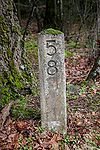 (2020) |
| MP 70 | Historic Columbia River Highway State Trail near Mosier Twin Tunnels | Replaced | Rediscovered by 1987 in poor condition[5], likely replaced with restored milepost by 2000 | — |
| MP 213 | Oregon Trail interpretive sign at the corner of US-30 and Old Pendleton River Rd. in Pendleton | Excellent | Mileposts moved to this location prior to 2015 to prevent further vandalism and theft | — |
| MP 215 | Good | — | ||
| MP 216 | Good | — | ||
| MP 225 | Excellent | — | ||
| MP 239 | Excellent | — | ||
| MP 340 | Old US-30 about 1 mile southeast of Baker City | Good | Rediscovered in September 2024 by Kirk J. Poole | — |
| MP 342 | Old US-30 about 3 miles southeast of Baker City | Fair/Good | — | |
| MP 343 | Old US-30 about 4 miles southeast of Baker City | Good | — | |
| MP 346 | Old US-30 about 7 miles southeast of Baker City | Poor | Partially destroyed as of April 2012. Needs to be re-evaluated in the field. | — |
| MP 356 | Old US-30 about 6 miles northwest of Durkee | Poor | Partially destroyed as of April 2012, but has lots of exposed rebar; the "3" is mostly missing in both directions. Needs to be re-evaluated in the field | — |
| MP 360 | Old US-30 about 2 miles northwest of Durkee | Good | — | |
| MP 361 | Old US-30 about 1 mile northwest of Durkee | Poor | Partially destroyed and bent at an angle as of April 2012. Needs to be re-evaluated in the field | — |
| MP 383 | US-30 in Huntington | Excellent | — |
The Dalles-California Highway
| Milepost | Location | Condition | Notes | Photo |
|---|---|---|---|---|
| MP 3 | Eightmile Rd. near Petersburg | Poor | Exposed rebar, severe cracks; used to support a birdhouse | 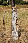 (2021) |
| MP 9 | Intersection of Eightmile Rd. and Emerson Loop Rd. | Good | One major crack, no chunks missing | 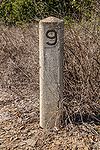 (2021) |
| MP 12 | Abandonned section of OR-23/US-197 off of Ward Rd. near Boyd | Good | Some small chunks missing | 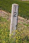 (2021) |
| MP 18 | South of intersection of US-197 and Helmrich St. near Dufur | Destroyed | Appears to have been damaged beyond repair for unknown reasons | 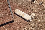 (2021) |
| MP 19 | Abandonned section of OR-23/US-197 south of Dufur | Excellent | Rediscovered in 2022 by Kirk J. Poole and Aaron F. Litt; still has black paint inside numerals and black band along bottom | 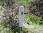 (2022) |
| MP 27 | Near south end of Dufur Gap Rd. between Dufur and Tygh Valley | Good | Rediscovered in 2022 by Kirk J. Poole and Aaron F. Litt; not upright, being used as part of a fence | 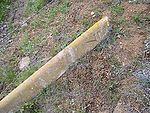 (2022) |
| MP 79 | NE Old US Highway 97 3 miles south of Willowdale | Good | Rediscovered in 2021 by Kirk J. Poole | 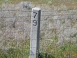 (2022) |
| MP 80 | NE Old US Highway 97 4 miles south of Willowdale | Poor/Fair | Rediscovered in 2021 by Kirk J. Poole; large chunks missing, kept standing with assistance of rocks placed at base | 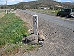 (2022) |
| MP 178 | Edge of US-97 ROW 6 miles south of La Pine | Removed | Rediscovered during ROW clearing at an unknown date; also removed from the field at an unknown date and given to the retiring maintenance manager at ODOT's La Pine maintenance station[6] | — |
Unknown
| Milepost | Location | Condition | Notes | Photo |
|---|---|---|---|---|
| MP 5 | 1600 block of SW Spring Garden St. in Portland | Good | Spring Garden St. was never a state highway, so this was possibly removed from the nearby Pacific or West Side Pacific Highway | 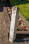 (2021) |
See Also
References
- ↑ Atcherman, Gail. Email to Laura Wilt, 14 July 2011
- ↑ 2.0 2.1 Medford Mail-Tribune. "Since You Asked: Old Mileposts Still on Highway 99," 7 October 2007
- ↑ Poole, Kirk J. Facebook Messenger chat with Jonathan Ledbetter, 30 October 2023
- ↑ Ochi, Diane. Columbia River Highway: Options for Conservation and Reuse, National Park Service, 1981, p. 104
- ↑ Gronowski, Nancy H. & Jeanette Kloos. A Study of the Historic Columbia River Highway, Oregon Department of Transportation, November 1987, p. 64
- ↑ Litt, Aaron F. Facebook Messenger chat with Jonathan Ledbetter, 3 May 2022
