Mileposts
Mileposts, also called mile markers, denote the distance between two termini on a highway or road. On state highways and county and local roads, the design and materials used for mile markers has changed drastically throughout the years.
Pre-State Highways
Portland Baseline Mile Makers
Not much is known about mileposting of roads in Oregon prior to the creation of the OSHD, but the mile markers along Portland's Stark Street (formerly Baseline Road) are some of the oldest such mileposts in the state.
After John Preston, first Surveyor General for the Territory of Oregon, marked the intersection of the Willamette Baseline and the Willamette Meridian in June 1851, a road was soon built along the baseline east of Portland[1]. Appropriately called "Baseline Road", it was opened on November 24, 1854[1]. Some time after that, 15 stone mileposts were placed eastward along Baseline Road from the courthouse to the Sandy River, one stone per mile, using the Multnomah County Courthouse (between SW 4th/5th Avenues and Main/Salmon Streets) as the zero milepoint[1]. While no one is sure who placed them or when they were placed, it is believed to have been done in the 1870s by the United States Army operating out of the barracks on Front Street and Madison Avenue; they used a one-mile long rope tied to a wagon's axle to make the measurement[1].
Surprisingly, 9 of the original 15 markers survive today, which is even more incredible given the amount of widening Baseline Road/Stark Street has undergone the past 150 years; the downside is that none of the markers are likely in their original locations as a result[1]. Mile markers 1, 3, 8, 10, 12 and 15 are missing; all others have been preserved, rescued and/or reinstalled at some point in their history. The plaque in Ventura Park lists mile marker 11 as missing; however, it was since recovered in 1998 and re-set in 2000 with additional concrete[1].
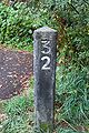
It is believed that this process was repeated for roads heading in three other directions from Portland: Northerly along St. Helens Road/Lower Columbia River Highway (present-day US-30), southerly along a road near the West Side Pacific Highway, and westerly along Jefferson Street/Canyon Road or Burnside Street[1]. One mile marker, P7, can be found outside the Capitol Hill branch of the Multnomah Public Library on SW Captiol Highway along the supposed southern route. Otherwise, no other mile markers have been found along any other routing, despite rumors that three mile stones exist along the northerly alignment[1].
- P Mile Markers Around Portland
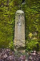
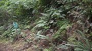
Baseline marker P2 embedded into a concrete wall on SE Stark Street in Portland, 2016
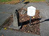
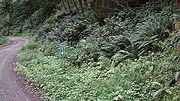
Baseline marker P7 in Ventura Park at the corner of SE Stark Street and 117th Avenue in Portland, 2013
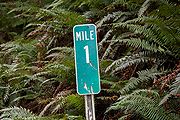
Southern baseline marker P7 at the Capitol Hill branch of the Multnomah Public Library in Portland, 2013


State Highways
Concrete Mileposts
Original Mileposts
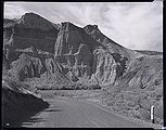
Concrete mileposts were first plotted in 1913 along the entirety of the Columbia River Highway, from Astoria to The Dalles. The zero milepoint was in Portland, at the corner of SW Washington Street and Broadway; from there, mileage increased both easterly to The Dalles and westerly to Astoria[2]. They were triangular in design, about 3-4 feet tall, with the number carved into the two sides facing traffic.

In 1923, the OSHD audited its major highways, including the Columbia River Highway, to compile a list of features along the roads for recordkeeping and maintenance purposes; these lists became the 1924 "Mile Posting Data" log for each highway, a precursor to straightline charts that ODOT still uses today[3]. On September 25 that same year, newly appointed Oregon State Highway Engineer Roy A. Klein proposed placing mileposts along "all main state highways" to the OSHC[4][5]. Klein was instructed by the commission to report on the cost of this proposal at the next meeting, but he would not present his findings until the November 27 meeting — and even then, he only requested (and received approval for) placing them along the Pacific Highway from Portland to the California line[5][6]. Later, on February 5 1924, Klein was authorized by the OSHC to continue his milepost surveys along the West Side Pacific Highway from Portland to Junction City, as well as the Columbia River Highway (and the Old Oregon Trail Highway by extension) from Astoria to Ontario[7].
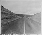
The Sixth Biennial Report of the Oregon State Highway Commission, published in 1924, features a photograph between pages 78 and 79 of one such concrete milepost, MP 58, along the Pacific Highway a few miles south of Salem. The report also describes their placement along five major highways, as well as their purpose:
Concrete mile posts indicating the distance from Broadway and Washington streets, Portland, have been set on the entire length of the Pacific and West Side Pacific Highways, also the Upper and Lower Columbia River Highways and Old Oregon Trail through to Ontario. These mile posts, having been accurately set, become an interesting and informative guide to tourists as well as affording valuable aid in designating maintenance operations, etc. Supplementing the mile posts, each bridge, culvert or other structure has been measured in and indicated on the department records with the proper decimal of the mile in which it is located. This permits the immediate location of all bridges and structures[8].
While the report only mentions the highways that would become US-99/99E/99W and US-30, OSHD policy at the time was to place "permanent concrete mileposts on all our main state highways"[9].
Due to realignments, widenings, theft and other reasons, very few original concrete mileposts have survived to the present day, with even fewer of them in their original locations. By 1987, only three original concrete mileposts existed along the entirety of the old Upper Columbia River Highway, with only two of them (mileposts 14 and 58) still in good condition into the present day[10].
In addition to the highways above, concrete mileposts have also been discovered along former and abandoned alignments of The Dalles-California Highway in The Dalles-Dufur region and a few miles south of Willowdale. Klein was permitted to place a set of concrete mileposts along this highway on September 28, 1926[11]. The designs of these mileposts are similar to the ones found on the Pacific and Columbia River Highways, but were slightly changed; the points on the triangular columns of these posts appear rounder and visible stamp outlines can be made out around the numbers.
The last known sets of concrete mileposts requested by Klein were for the Redwood Highway #25 (now US-199), Sherman Highway #42 (now US-97) and John Day Highway #5 (now OR-19 and US-26), approved on March 8 1929[12]. So far, no concrete mileposts have been found on those highways.
Locations
Restored Historic Columbia River Highway Mileposts

The need for milepost restoration along the old Columbia River Highway was identified as far back as 1981. In her National Park Service report Columbia River Highway: Options for Conservation and Reuse, Diane Ochi recommended adding back mileposts along the route as part of a unified signage overhaul along the route[13]. The newer mileposts would be of similar design to the original ones, but were more informational and intricate in design and placement:
- When installed, the posts would be oriented to point to the north.
- "Columbia River Highway" would appear underneath the number, rotated clockwise 90 degrees in order to fit on the post.
- Both the number and "Columbia River Highway" would be surrounded by a rounded-rectangular border, beveled at the same depth as the letters (¼-inch).
- The installation or designation year ("1981" in the etching) would be inscribed on top of the post.[13]
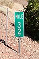
Ochi's grand vision for the new Columbia River Highway mileposts did not come to fruition, but the idea of milepost restoration along the highway lived on. By 1987, the state had allocated $10,000 to ODOT to cast and place concrete replacement mileposts along two state-owned portions of the old highway, the Crown Point Highway and the Mosier-The Dalles Highway[14]. These mileposts were similar in design and size to the ones originally placed along the highway, but the numbers were thicker and were painted white. Later projects, including the restorations of the Ruthton Point Viaduct and the Mosier Twin Tunnels, also received these mileposts. However, it is not known at this time if recently opened HCRH Trail segments have these stone mileposts on them.
Restored HCRH Milepost 32 just west of Multnomah Falls, 2013

Restored HCRH Milepost 63 at Ruthton Point, 2019


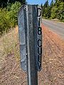
Wooden Mileposts
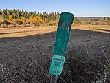
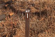
At some point after 1929 — possibly due to the onset of the Great Depression — the OSHD started utilizing wooden mileposts on its highways. The earliest designs consisted of wooden logs buried in the ground, with the exposed part painted a light color (likely white) on top and the bottom/unexposed part painted a dark color (likely black). On the lighter part, large dark numerals were painted on the side. The top was pointed. The scope of the usage of these mileposts is unknown at this time, but they have been found on multiple state highways. One (MP 116) was photographed along the John Day Highway #5/OR-19[15], and another (MP 169) was photographed along the Central Oregon Highway #7/US-20 circa June 1955[16]. It is not immediately known if numbers were painted on both sides (though it would seem likely).
Later versions were square wooden posts with the number carved into the wood, similar to how concrete mileposts have the numbers etched into them. They too were painted white with black numerals and a black portion on the bottom, and also had a pointed tip. One such example that survives as of July 2025 is MP 43 along US-30 slightly east of Cascade Locks, likely placed around 1952 when the Cascade Locks-Herman Creek Road section of the highway was realigned.
In addition to the concrete markers ordered in 1926, wooden markers were also discovered (and removed) along The Dalles-California Highway/US-97[17]. This, along with MP 43 in Cascade Locks using realigned mileage, indicates that concrete mileposts were likely replaced by wooden mileposts due to highway realignment, theft or destruction.
Round wooden milepost 116 on John Day Highway (OR-19) near Fossil Mountain, undated
Round wooden milepost 169 on Central Oregon Highway (US-20) near Stinkingwater Creek, 1955
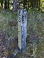
Square wooden milepost 43 on Historic Columbia River Highway (US-30/Historic US-30) in Cascade Locks, 2025
.jpg)


MUTCD-Compliant Mileposts

1961 Standards
The 1961 edition of the MUTCD introduced mileposts into the standard, discussing their purpose, placement, zero-milepost orientation, and design[18]. Owing to their uniformity of standards, mileposts on Interstate freeways had a very specific color scheme and numeral size:
The Milepost panels are green, with 6-inch white reflectorized numerals[18].
The standard allowed more leeway for non-Interstate highways, allowing three different color schemes and two different numeral sizes:
It is recommended that these be simple panels, without border, having 4- to 6-inch numerals and no other legend. The numerals should be black on a white background or white on a green or black background, with suitable reflectorization[18].
Aside from the colors, numeral sizes, and the lack of border and other legends (which also applied to Interstates), no other guidance was given on other aspects such as shape, size, typeface, or numeral orientation.
When Oregon implemented mileposts according to their interpretation of the 1961 specification, they used green metallic panels 24 inches tall and 8 inches wide, with 6-inch numerals center-aligned descending from the top of the panel. The numerals were in reflectionized FHWA Gothic Series E and were not rotated. The panel was the same size regardless of how many digits were on it and the type of highway it was placed on. Almost none had borders on them.
The prevalence of these mileposts along state highways diminished in the 1980s and 1990s due to reconstruction projects and updated reflectionization standards; as a result, very few of these mileposts remain, occasionally on former state highways turned back over to county control:
- On US-101 in Depoe Bay, two could be found at MP 128 as of 2018, but were removed by 2024. Both were in good condition.
- One can be found on OR-47 outside of Mist at MP 49 as of 2021. It was in excellent condition.
- One can be found on OR-99E just north of Hubbard at MP 28 as of 2019. It appeared to be in good condition.
- A few can be found on OR-210/Scholls Ferry Road between Kinton and Scholls at MP 2 and 3 as of 2021; MP 4 was present into the mid-2010s, and westbound MP 1 was present until the Tualatin River Bridge near Scholls was rebuilt in 2008. All still present in 2021 appeared to be in poor condition, but could also just have been extremely dirty.
- A pair could be found on OR-8 at MP 1 in Beaverton until the late-2010s. These ones were unique in that they had a border around them, a deviation from the 1961 spec. The westbound one was removed sometime around 2017 and the eastbound one around 2020. Both have since been replaced with modern mileposts. Prior to removal they were in good condition.
- One could be found on OR-10 westbound at MP 3 before it was removed sometime after 2002.
Others may still exist elsewhere in the state on present and former alignments.

A pair of 1961 spec mileposts mounted on a single post at MP 128 on US-101 South in Depoe Bay, 2016
A single 1961 spec milepost at MP 49 on OR-47 North near Mist, 2021
A single 1961 spec milepost (with added border) at MP 1 on OR-8 West in Beaverton, 2015
Another 1961 spec milepost milepost at the same spot eastbound on the same highway, 2018

A 1961 spec milepost hiding on the back of a weight limit sign on OR-99E near Hubbard, 2021


1971 Standards
AASHO revamped their standards in 1971, tightening up the variances in color, shape and size previously allowed. Also, borders and the word "MILE" were added in a complete reversal from the 1961 spec[19]. The previous requirements for Interstates were rolled into general requirements for freeways in this edition, and required larger mileposts:
Markers shall contain 10-inch white numerals on 12-inch wide vertical green panels with a white border. Panels shall be 24″, 36″, or 48″ in length for one, two, or three digits, respectively, and contain the word MILE[20].
Markers on non-freeways were just smaller versions of the freeway ones:
Milepost signs shall be vertical panels with 6-inch white numerals, a border and the word MILE in 4-inch letters on a green background and shall be reflectorized[19].
Three sizes were specified, based on how many numbers would be on the post:
- D10-1: For 1-digit numbers, 12″ × 24″ on freeways[20], 10″ × 18″ elsewhere[19]
- D10-2: For 2-digit numbers, 12″ × 36″ on freeways[20], 10″ × 27″ elsewhere[19]
- D10-3: For 3-digit numbers, 12″ × 48″ on freeways[20], 10″ × 36″ elsewhere[19]
Aside from the size of the numbers and the MILE legend, no typeface suggestions were given. However, the example image in the MUTCD itself appears to use FHWA Gothic Series D for the numerals and Series B for the MILE legend[19].
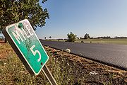
Oregon mostly adopted the milepost standard as defined in the MUTCD. However, the state opted to use the D10-2 2-digit marker for 1-digit mileposts, with the number vertically centered between MILE and the bottom of the post. This practice was utilized on both freeway and non-freeway routes through the mid-2000s, when ODOT started using the D10-1 marker more frequently for single-digit mileposts. Recently completed transportation projects, like the Sunrise Expressway and the Rogue Valley Expressway, use D10-1 single-digit panels.
Two of Oregon's first major implementations of the 1971 standard mileposts occurred around early 1972, when the entirety of mileposts on Interstates 5 and 80N were replaced. Interstate 5's mileposts were originally from north to south, but needed to be switched to running south-to-north, per 1961 AASHO standards; Interstate 80N's mileposts were being changed to incorporate increased mileage from the selection of the Mount Hood Freeway corridor. State Highway Engineer R. L. "Rod" Porter estimated that the cost of revising both highways' milepost systems and installing the new mileposts would cost $25,000 total — $11,500 for I-5 and $13,500 for I-80N — and would need to be done with state forces instead of by several contractors[21].
Technically, just about any milepost on a state highway in Oregon that only includes a border, a MILE legend and large numbers on whole miles is a 1971 specification MUTCD milepost. That said, Oregon does have quite a few subtle variations based primarily on number size and typeface, usually FHWA Series C or D. In addition, later MUTCD specs included variations that Oregon has implemented from time to time.

2003 Standards
The 1971 MUTCD descriptions for mileposts remained more or less the same for more than 30 years, even after a name change to the more generic "reference posts" in 2000. These standards also allowed for fractional mileposts of some kind, using either delimiters or reference posts at consistent intervals. However, they weren't considered part of the milepost system until 2003, when AASHTO introduced them as "intermediate reference location markers". These mileposts have the same design as the 1971 spec, but with an extra section below the mile number that contains the fractional portion, with decimal (such as ".3")[22]. The decimal portion is always displayed, even on whole numbers where a ".0" is placed in that section.
The 2003 MUTCD defined sizes for freeway and expressway placement, but not for other highways and roads. Their dimensions are estimated based on the original D10 mileposts of comparable size.
- D10-1a: For 1-digit numbers – 12″ × 36″ on freeways, 10″ × 27″ elsewhere[22]
- D10-2a: For 2-digit numbers – 12″ × 48″ on freeways, 10″ × 36″ elsewhere[22]
- D10-3a: For 3-digit numbers – 12″ × 60″ on freeways, 10″ × 45″ elsewhere[22]
Oregon's first implementation of this standard, however, was not for fractional mileposts. Instead, the mileposts were used to differentiate between sections of US-395 where mileposts reset to zero due to Oregon's dual highway/route system. This resetting confused travelers at best and hindered emergency services at worst, so ODOT decided to add letters in the spot on the post where the fraction would normally reside[23]. ODOT initially added them on two sections in late 2008 or early 2009 — the section of US-395 from Pendleton to Mt. Vernon received "B" while the section from John Day to near Burns received "C"[24]. Letter suffixes "D" and "E" were added to two portions from near Riley to the California border by 2013[23]; these ones omit the line between the numbers and letter, making them effectively like an original D10 milepost with 4 alphanumerics on them.
The letter suffix system was expanded to OR-207 by early 2018, using "A", "B" and "C" along three different sections[25].
As far as actual fractional mileposts are concerned, their first usage in Oregon was on US-26 between Sandy and the junction of OR-35, installed at half-mile intervals in the summer of 2011 as part of and ODOT pilot project[26]. Since then, Oregon has expanded their usage on other highways to improve response times. Freeway-size D10-2a markers has been installed at half-mile intervals in the median of I-84 through the Columbia River Gorge, and smaller D10-1a mileposts were installed on the Multnomah County section of then-future OR-127 in the summer of 2019[27].
ODOT had placed a D10-2a marker at MP 68.9 along US-26 near Clear Creek in the Mount Hood National Forest in an attempt to avoid the "Mile 69 Problem". Unfortunately, it was removed by October 2022, likely the result of construction along that segment; as of June 2025, it has not been replaced.
An August 2014 I-5 optimization study recommended installing half-mile markers between Salem and Albany for incident management and towing purposes[28]. However, as of 2024 this has yet to come to fruition. Tenth-mile markers were also considered, but ultimately were not recommended[29].
A D10-1a milepost at MP 9 on OR-207 near Hardman, with a letter suffix to distinguish between three sections of the same route, 2021

A D10-1a milepost at MP 3.5 on Cornelius Pass Road (now also OR-127) just north of the intersection with Skyline Blvd., Multnomah County, 2020

A D10-2a milepost at MP 27.0 on US-26 east of Sandy, 2017 (since replaced with a standard D10-2 marker)

A D10-2a milepost at MP 36.5 on US-26 west of Mt. Hood Village, 2017

A D10-2a milepost at MP 68.9 on US-26 near Clear Creek (since removed), 2021
A large D10-2a milepost at MP 31.5 on I-84/US-30 at Multnomah Falls, 2021


2009 Standards
The 2009 standard added another milepost type, "enhanced reference location signs", to further aid motorists and emergency responders[30]. These mileposts contained a cardinal direction, route shield and whole mile number. Two different varieties were defined, one for whole numbers (D10-4) and one for fractional miles (D10-5) which included an extra section below the mileage for the decimal part. Both varieties only came in one size, regardless of mile number or highway type:
- D10-4: For whole miles only – green or blue, 18″ × 54″[31]
- D10-5: For whole and fractional miles – green or blue, 18″ × 60″[31]
Legends need to be at least 6 inches tall and shields need to be at least 12 inches tall[30]. For typefaces on both, the examples in the MUTCD showed the cardinal direction and whole mile number in FHWA Series B, and with "MILE" and the fractional mile (if present) in Series C.
Oregon doesn't use these type of mileposts very often, but they are present in the state. D10-5 markers were installed at half-mile intervals along OR-217 in the summer of 2011 as part of the same pilot project that installed 2003-spec D10-2a markers along US-26[26]. These markers largely matched those in the MUTCD, but used FHWA Series C for the whole mile number instead of Series B. As of 2021 they do not appear to have been implemented along any other freeway within Oregon.
In addition, D10-4 mileposts can be found in a rare non-freeway instance intermittently along US-20 through the Cascades. Installed around 2016 or 2017, these ones more or less follow the MUTCD example typeface-wise. Some examples can be found at MP 75, MP 80 and MP 83.
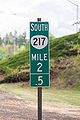
A D10-5 milepost at MP 2.5 on OR-217 South in Beaverton, 2021
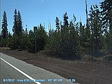
A D10-4 milepost at MP 80 on US-20 East in the Cascades, 2017

_MP80.035-EB.jpg)

Terminal Mileposts
Oregon initially didn't post any mileposts at a highway's termini, save in the rare instance where a highway ended its mileage at or around the whole mile — one such example is MP 50 at the end OR-224 just across the bridge over the Oak Grove Fork of the Clackamas River. Prior to 2000, "BEGIN" and "END" banners were not present on state highways in Oregon at either terminus. For unsigned state routes that continued beyond the end of state maintenance, the change in jurisdiction (if indicated at all) was either indicated by an "END STATE HIGHWAY MAINTENANCE" sign or some sort of county signage indicating the start of their maintenance. The new millennium ushered in a few "END" shield assemblies on some signed state routes, and even a "BEGIN" assembly or two (such as the "BEGIN US-20" assembly at its western terminus, US-101 in Newport).
At the tail end of the 2010s, Oregon started experimenting with terminal mileposts in different parts of the state. Along the I-5 corridor, ODOT posted D10-2 zero mileposts along two intersecting signed state highways: At the northern terminus of OR-551 and at the junction of I-5 and OR-99E Business in Keizer. These are possibly the first zero mileposts along a state-maintained highway in Oregon. The "0" numeral (in what looks to be FHWA Series D) is considerably larger than numerals used in standard D10-2 mile markers.
In addition, by June 2021 ODOT Region 3 had marked the ends of some of its unsigned/poorly-signed state maintained highways with distinctive panels. The words "END ODOT" would be stacked on top, followed by the ODOT logo, then "MP" over the terminal milepost number to two decimal spots (or "0.0" at the zero milepoint), and finally the name of the highway over "HWY. ###" — with "###" being the state highway number, not the state route number. So far they have been observed at termini on highways in both Coos and Curry County: OR-241, OR-542, OR-250, and OR-251[32][33].
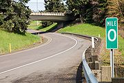
A rare zero milepost at the northern terminus of OR-551 at I-5 south of Wilsonville, 2020

Miscellany
- Rarely, some mileposts will have a "Z" above the number, such as on a section of US-101 near Wheeler. This is due to a highway realignment or cancellation and is used to denote duplicate mileposts along a highway, and is similar to "B"-mileage in Washington or "R"-mileage in California. For additional information on Oregon's milepoint system, see Mileposting in Oregon.
County Roads

Clackamas County
Three different kinds of mileposts can be found on Clackamas County roads:
- Green MUTCD D10-2 mileposts for 1- and 2-digit numbers, marked at whole miles
- White metallic rounded rectangles, marked at culverts in hundredths of a mile
- White delineator wickets embedded in the ground, also marked at culverts in hundredths of a mile
Each of these mileposts contains the mileage — whole numbers on green mileposts, tenths or hundredths of a mile on white ones — and a 5-digit county road number. This number can sometimes span two different roads if they comprise a longer route, such as Stafford and Wilsonville Roads.
The green mileposts used to be more prevalent in the 1990s but have been disappearing as they're damaged or otherwise removed. The white markers are much more prominent, but can be more hidden and sometimes don't face traffic.
At jurisdictional boundaries, the white markers can also sometimes be found with "BCM" and "ECM", for "begin county maintenance" and "end county maintenance" respectively, depending on the direction of travel. On the wickets, no other information (such as mileposts or road numbers) are present; the metal rectangle versions of these posts can contain the road number, but again no mileage is indicated.
Zero mileposts can be found among all three types, though the green ones are much rarer.

A D10-2 milepost at MP 1 on SW Mountain Rd. near Stafford, 2013
A white rectangular milepost on SW Homesteader Rd. near Stafford, 2013
A white wicket milepost on SE Fireman Way in Boring, 2017
A white rectangular milepost on E Salmon St. near Brightwood, 2017

A damaged D10-2 milepost at MP 4 on SW Borland Rd. near West Linn, 2017
A white "begin county maintenance" marker on SW Ladd Hill Rd. near Sherwood, 2020

A white "begin county maintenance" wicket on SW Carman Dr. in Lake Oswego, 2021

A white "end county maintenance" wicket on SW Carman Dr. in Lake Oswego, 2021


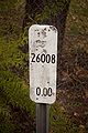
Clatsop County
Prior to the mid 2010s, mileposts on Clatsop County roads appeared only on green wickets placed in the vicinity of a culvert. These wickets show the mileage in tenths, hundredths, or even thousandths of a mile, without identifying any sort of road name or number. The typeface used is a thinner stroke version of Helvetica Inserat Roman.
In early 2015, some roads were provided with mileposts in three new distinct styles, leaving the green wickets intact:
- A standard D10-1 or D10-2 milepost, mounted on a post in the center with numbers in FHWA Series C or D. Some enhancements have also been added:
- The 2-digit year of manufacture or installation is in black in the upper right
- The road name and number are in white on the bottom towards the left
- "Clatsop County" is in black on the lower right
- The month and year of installation may be written in permanent marker somewhere on the milepost
- A different D10-1 (and possibly D10-2) milepost, mounted on a post to the side; in addition, the 2-digit year, "Clatsop County" stamp and written installation date are omitted. On these markers, the numbers are in FHWA Series B.
- A white wicket with a green sticker stating "MILE" and the mile number. All letters and numbers are in condensed FHWA Series C.
Other variations may also exist, but have yet to be discovered or documented.
In addition, inventory markers placed on county bridges display the milepoint number alongside other bridge information.
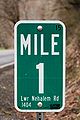
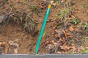
A centrally-mounted D10-1 milepost at MP 1 on Lower Nehalem Rd. south of Elsie, 2018

A side-mounted D10-1 milepost at MP 5 on Lower Nehalem Rd., 2021

A centrally-mounted D10-2 milepost at MP 10 on Lower Nehalem Rd. near the Tillamook County line, 2021

A white wicket milepost at MP 1 on Red Bluff Rd. near Elsie, 2021

A white wicket milepost at MP 6 on Hamlet Rd. near Hamlet, 2021

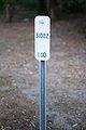
A green wicket culvert marker at MP 9.02 on Lower Nehalem Rd., 2014
A green wicket culvert milepost at MP 5.9 on Hamlet Rd. near Hamlet, 2021

A green wicket culvert milepost at MP 0.157 on Saddle Mountain Road near Olney, 2021
A green wicket culvert milepost at MP 0.009 on Youngs River Road near Olney, 2021


Columbia County
Columbia County does not place mileposts along all of its roads, but does on some major ones like Apiary Road and Scappoose-Vernonia Highway. When they are placed, they are standard D10-1 and D10-2 mileposts with the numeral in FHWA Series D. No other markings or information appears to be on the signs themselves.

Coos County
Coos County has used their own version of an "enhanced" milepost for at least 20 years, though overall it appears more in line with the 1961 MUTCD spec. It consists of a simple green rectangle 6″ × 18″ with no border or "MILE" legend, with a FHWA Series C numeral roughly centered at the top of the sign. Below the numeral is a square sticker of a Coos County reassurance shield with the road number placed inside. The road number is also in Series C, but the "COOS COUNTY" inside the shield appears to be different weights of Helvetica Neue LT Pro; "COOS" is in 87 Heavy Condensed and "COUNTY" is either 77 Bold Condensed or 67 Medium Condensed.

Douglas County
Douglas County places its mileposts at mile intervals along many of its county roads, using two distinct styles:
- The first style is similar to the state's 1961 MUTCD spec marker, except it's smaller, shorter and uses Series E(M) for its numerals instead of Series E.
- The second, much more common style follows the 1971 MUTCD spec, using a D10-2 for 1-digit mileages and a D10-3 for 2-digit mileage, using Series B, C or D.
Both mileposts leave a space below the numeral for a sticker or decal of a Douglas County reassurance shield with the road number placed inside, similar to Coos County. However, Douglas County's shields have a yellow background and are entirely in FHWA Gothic fonts; Coos County's shields have a white background, and some of the text is in Helvetica Neue LT Pro.

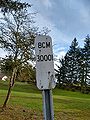
Hood River County
Hood River County mileposts its roads using a simple green panel with "MP" at the top and the number below it. The same size panel appears to be used for 1- and 2-digit numbers. Mileposts appear to be placed on the side of the road where mileage increases, with a mile marker facing each direction of travel. All characters appear to be in FHWA Series C.
There does appear to be some sort of hundredths marker that the county uses. Similar to other county mile markers, it is topped with "MP", but displays the two hundredths-mileage digits below the integer mile in smaller numbering, making these markers taller than the others. A version with black text on an aluminum background can be found on Baseline Drive at MP 0.46, with "D18 CULV" down the right side on the back; "CULV" indicates this is marking a culvert. Until roughly 2021, when it was replaced during freeway construction, a version with white text on a green background could be seen on Forest Lane at the I-84 overpass in Cascade Locks where the road becomes state-maintained. This one has "F4 END" also down the right side on the back, with "END" indicating the jurisdictional transition. It is currently unknown what "D18" and "F4" stand for, though it's possible they indicate route numbers or some other inventory number. It is also unknown if any other existing hundredths markers have text on their backs.

A mile marker at MP 2 on Cooper Spur Rd. near Parkdale, 2019

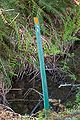
A hundredths mile marker at MP 1.18 on Forest Lane in Cascade Locks (since removed), 2019
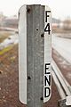
The reverse of the previous marker, 2019
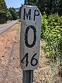
A hundredths mile marker at MP 0.46 on Baseline Drive near Parkdale, 2024
The reverse of the previous marker, 2024


Linn County
Linn County doesn't appear to place mileposts along its county roads. However, it does place inventory markers on bridges that displays the milepoint alongside other information.

Marion County
Marion County doesn't regularly place mileposts along its county roads. However, an old-looking MP 5 marker was rediscovered on Cascade Hwy SE just south of its junction with OR-214 as of June 2019. It was present at that location prior to October 2008 and was likely placed within the past 30-40 years, but has since been knocked at an angle. The marker is a standard D10-1 milepost with the numeral in FHWA Series C. The northbound (south-facing) side is much more deteriorated than the southbound (north-facing) side.
Additional research is needed to determine if any more markers exist along Marion County backroads.
A D10-1 milepost at MP 5 on northbound Cascade Hwy SE, 2024
That same D10-1 milepost, but on southbound Cascade Hwy SE, 2024

A closeup of the southbound milepost, 2024


Multnomah County
Multnomah County has used standard D10-1 and D10-2 mileposts along its roads since at least the mid-1980s, though they used to be more common than they are now. The large numerals are usually in FHWA Series C, but can also be found in Series D. They are commonly mounted on wooden posts with the top carved into a point, a typical feature of Multnomah County signage.
The county did place D10-1a mileposts at half-mile intervals along Cornelius Pass Road in 2019, but this was likely done in conjunction with ODOT in preparation to turn it over to state jurisdiction. Multnomah County milepost 5 was confirmed on Cornelius Pass Road at the Washington County line as of May 28, 2021, but was removed by January 2022.
A D10-1 milepost at MP 2 on SE Orient Drive (old OR-50/US-26) in Orient, 2017

A D10-1 milepost at MP 5 on Cornelius Pass Road (OR-127) on the Multnomah-Washington County Line (since removed), 2021


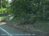
Tillamook County
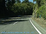
Prior to about 2015, Tillamook County largely used standard D10-1 and D10-2 mileposts along many of its county roads, with numbers typically using FHWA Series D. In some instances, a D10-1 milepost may have two digits; in other instances, a D10-2 milepost may have one digit. Some D10-2 mileposts had a thicker border and more space between the "MILE" legend and the numbers; the numbers themselves may also use a different FHWA Series, like Series C.
Around 2015, a new variety of milepost started appearing along some county roads, such as Foss Road and Fairview Road. These mileposts were more squarish in appearance with a much thicker white border around them, a much more reflective green background, and one or two digits inside. The numbers are FHWA Series B stretched about 30% wider than usual.
In addition, a smaller third type of milepost has been found on Gods Valley Road at MP 3. This milepost is roughly 6″ × 15″ with a thick white border and uses FHWA Series B in both the "MILE" legend and the number. Whether this type of marker is used on other county roads is unknown at this time.

A D10-1 milepost at MP 9 on Foss Road in rural Tillamook County, 2021
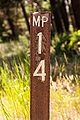
A D10-1 milepost containing two digits at MP 12 on Foss Road in rural Tillamook County, 2018
A D10-2 milepost at MP 14 on Foss Road in rural Tillamook County, 2014

A D10-2 milepost with a slightly different design at MP 11 on Foss Road in rural Tillamook County, 2014
A single-digit D10-2 milepost at MP 1 on Gods Valley Road in rural Tillamook County, 2021

A small milepost at MP 3 on Gods Valley Road in rural Tillamook County, 2021

Post-2015 MP 15 on Foss Road in rural Tillamook County, 2021

_MP12-NB(C2).jpg)
_MP14-NB(C2).jpg)
_MP11-NB(C2).jpg)


Umatilla County
Umatilla County appears to place D10-1 and D10-2 mileposts along many of its county roads. The designs are slightly modified from the standard to place "UMATILLA COUNTY" in small FHWA Series C text centered below the numeral on two separate lines, but are otherwise the same as other 1971 MUTCD spec mileposts. No other road information appears to be present on these signs.
Wasco County
Wasco County doesn't appear to place mileposts along its county roads.

Washington County
Mileposts along Washington County roads are pretty rare and usually aren't present at all. When they are, they are simple green rectangles 6″ × 18″ with no border, with "MP" and the number in the same size FHWA Series B typeface. They are usually — though not always — accompanied by a smaller green rectangle 6″ × 10″ with a thin white border bearing the text "WASHINGTON COUNTY ROAD" and the road number, both also in Series B. Due to their weathered appearance in the wild, it's likely these mileposts were placed more than 30 years ago. Only a handful are known to have survived into the 2010s:
| Road | Milepost | Location | Direction | Status |
|---|---|---|---|---|
| NW Jackson School Road | MP 1 | North of NW Mason Hill Road, near North Plains | Southbound | Present as of July 2025, but missing its road number plaque |
| SW Bull Mountain Road Washington County #20272 |
MP 2 | Intersection with SW 150th Ave., Tigard | Eastbound | Removed sometime after February 2015 |
| SW 185th Avenue Washington County #35185 |
MP 3 | Across from Burnside Park, Aloha | Southbound | Removed sometime after October 2014 |
| River Road | MP 3 | South of intersection with Rosedale Road, near Hillsboro | Southbound | Present as of June 2025, but missing its road number plaque and possibly the "MP" legend |
| NW West Union Road Washington County #52626 |
MP 4 | West Union Elementary school, near West Union | Eastbound Westbound |
As of June 2021, westbound marker present but eastbound marker removed |
| NW West Union Road Washington County #52626 |
MP 6 | Between intersections of NW 208th Avenue and NW 205th Terrace, near West Union | Westbound | Present as of October 2020 |
Others may still exist along Washington County backroads.
Older state mileposts can also be found on sections of state routes turned back over to county jurisdiction. 1961 MUTCD specification posts are present as of 2021 at MP 2 and 3 along OR-210/Scholls Ferry Road; MP 4 near Kinton was present until the mid-2010s. A 1971 spec MP 12 also exists at the north end of Scholls Ferry Road near OR-10/Beaverton Hillsdale Highway. On OR-10/Farmington Road, a 1971 spec MP 3 was present eastbound as of August 2018; a 1961 spec milepost at that same location westbound was removed sometime after 2002, and other 1971 spec mileposts were removed over a 10-15 year period after that section of OR-10 was relinquished to the county.
Curiously, Washington County placed a D10-1 standard "MILE 1" marker on Scholls Ferry Road in Scholls at milepoint 1 of the old Scholls Highway #143 when the Tualatin River bridge was rebuilt in 2008. These markers — possibly the only MUTCD standard mileposts placed by Washington County — replaced a 1971 spec marker eastbound and a 1961 spec marker westbound.

Milepost 2 at the intersection of SW Bull Mountain Road & 150th Avenue in Tigard, 2015 (since removed)
Milepost 4 on NW West Union Road near Helvetia, 2021
Milepost 6 on NW West Union Road near West Union, 2020


Yamhill County
Yamhill County doesn't appear to place mileposts along its county roads.
Other Jurisdictions
Native Reservations

Warm Springs Reservation
Mileposts have been observed along BIA-3 and BIA-9 inside the reservation. They are standard green 1971 D10-1 and D10-2 mileposts, with numerals usually in FHWA Series C. Some variants have been seen, such as using FHWA Series D numerals or using a D10-2 milepost for a single-digit milepoint. Other styles may exist on other BIA roads.
Mileposts appear only to be posted in the direction of increasing mileage, when they are posted at all.
Milepost 32 on BIA-3 between Wapinitia and Simnasho inside the Warm Springs Reservation, 2025

National Forests
It is unknown at this time if all National Forests in Oregon use mileposts on their roads. However, these ones have been observed:

Mount Hood National Forest
So far, two types of mileposts have been observed along National Forest primary routes in the Mount Hood National Forest. The older type is a simple brown wicket with "MP" across the top and a larger mile number below. All text is in FHWA Series C. If the mile number is larger than 9, the number itself is stacked like a standard milepost. These mileposts have been observed on both National Forest 44 and National Forest 46. Varieties found on National Forest 43 use stickers for the "MP" in an as-yet-unidentified heavyweight sans-serif font (likely in the Helvetica family), with the number in FHWA Series B. Additionally, mileposts on National Forest 42 entirely use stickers featuring that same unidentified font.
In January 2025, a newer milepost design was observed along National Forest 57 east of its junction with National Forest 44 and Oregon 224. This type also uses a brown wicket, but has the word "MILE" on top in small FHWA Series E, the mile number below that in FHWA Series C, and a tiny route number at the bottom in FHWA Series B. The route number is in the format "NFxx", where "xx" is replaced by the route number (e.g., "NF57"). It is unknown if the mile number is stacked when greater than 9. As the area around National Forest 57 was heavily damaged by the Riverside Fire in September 2020, it is theorized that these mileposts were installed sometime afterwards.
No mileposts were observed along National Forest 48 between National Forest 43 and Oregon 35 in July 2025.
It is unknown at this time if mileposts exist on National Forest primary routes apart from National Forest 42, 43, 44, 46 and 57, or if they appear on secondary or tertiary forest roads and trials. It is also unknown at this time if the newer milepost design will be applied to other primary routes within the forest.
Milepost 14 on National Forest 44 near the eastern boundary of the Mount Hood National Forest near Dufur, 2022

Milepost 5 on National Forest 43 north of US-26, 2025
Milepost 1 on National Forest 46 south of Ripplebrook, 2025
Milepost 2 on National Forest 57 between Ripplebrook and Lake Harriet, 2025


State Forest and Timber Lands
It is unknown at this time if all state forests in Oregon use mileposts on their roads. However, these ones have been observed:

Clatsop State Forest
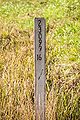
Some roads within the Tillamook State Forest have mileposts, usually nailed to a tree. They are yellow rectangular signs with a large black mile number centered on the sign. The number is usually in Helvetica Inserat, but other fonts like Franklin Gothic Heavy may be used. The signs don't contain any other information that identifies the road.
Most likely, these mileposts are placed by the Oregon Department of Forestry to aid both recreational vehicles and logging trucks. They are usually placed at half-mile intervals, but can sometimes go missing. Usually, mileposts are posted in pairs so as to be seen in both directions of travel.
On occasion, the milepost will be surrounded by spray paint on the tree to improve visibility.
Unlike other jurisdictions, fractional mileposts use vulgar fractions (e.g., ½) instead of decimal fractions (e.g., 0.5). The vulgar fraction portion appears to be in a condensed version of Helvetica in medium weight.
Milepost 2 on Quartz Creek Road near Flat Iron Mountain, 2019


Tillamook State Forest
Some roads within the Tillamook State Forest have mileposts, usually nailed to a tree. They are yellow rectangular signs with a large black mile number centered on the sign. The number is usually in Helvetica or a typeface similar to Frutiger or Calibri, but other fonts may be used. The signs don't contain any other information that identifies the road.
As the mileposts persist on roads that leave State Forest lands, it is unknown who places the mileposts along these roads. Most likely, they are placed by the Oregon Department of Forestry to aid both recreational vehicles and logging trucks. They are usually placed at half-mile intervals, but can sometimes go missing. Usually, mileposts are posted in pairs so as to be seen in both directions of travel.
On occasion, the milepost will be spray-painted on a tree instead of using a sign.
Milepost 4.5 on Cochran Road west of Reehers Camp, 2024
Milepost 6 on Cochran Road near Cochran, 2024


References
- ↑ 1.0 1.1 1.2 1.3 1.4 1.5 1.6 1.7 Felker, Jeff. "The Willamette Stone and the Baseline Rd Markers," The Stark Street Mile Markers blog, 23 May 2008, last accessed 8 May 2021
- ↑ Taylor, Michael C. Road of Difficulties. Bear Creek Press, Wallowa (Oregon), 2008, p. 27
- ↑ Unknown author. Internal ODOT memo, 2005
- ↑ Oregon State Highway Commission minutes, 26 June 1923, p. 1548
- ↑ 5.0 5.1 Oregon State Highway Commission minutes, 25 September 1923, pp. 1579-1580
- ↑ Oregon State Highway Commission minutes, 27 November 1923, p. 1614
- ↑ Oregon State Highway Commission minutes, 5 February 1924, p. 1643
- ↑ Sixth Biennial Report of the Oregon State Highway Commission, 1924, p. 16
- ↑ Klein, Roy letter to C. H. Purcell, 6 August 1924
- ↑ Oregon Department of Transportation. A Study of the Historic Columbia River Highway, November 1987, p. 64
- ↑ Oregon State Highway Commission minutes, 28 September 1926, pp. 2054-2055
- ↑ Oregon State Highway Commission minutes, 8 March 1929, p. 2462
- ↑ 13.0 13.1 Ochi, Diane. Columbia River Highway: Options for Conservation and Reuse, National Park Service, 1981, p. 89
- ↑ Gronowski, Nancy H. & Jeanette Kloos. A Study of the Historic Columbia River Highway, Oregon Department of Transportation, November 1987, p. 119
- ↑ Oregon Secretary of State, Oregon Records Management Solution. "John Day Highway With Fossil Mountain mile Post 116 (Wheeler)." Undated, accessed 13 January 2024
- ↑ Oregon State Highway Department via ODOT Library. "Central Oregon Highway MP 169." circa June 1955
- ↑ Litt, Aaron F. Facebook Messenger chat with Jonathan Ledbetter, 3 May 2022
- ↑ 18.0 18.1 18.2 AASHO. Manual for Uniform Traffic Control Devices, 1961 Edition, June 1961, p. 110
- ↑ 19.0 19.1 19.2 19.3 19.4 19.5 AASHO. Manual for Uniform Traffic Control Devices, 1971 Edition, 13 November 1970, pp. 110-111
- ↑ 20.0 20.1 20.2 20.3 AASHO. Manual for Uniform Traffic Control Devices, 1971 Edition, 13 November 1970, pp. 164 & 166
- ↑ Porter, R. L. letter to R. E. Simpson, 9 December 1971, p. 1
- ↑ 22.0 22.1 22.2 22.3 AASHTO. Manual for Uniform Traffic Control Devices, 2003 Edition, November 2003, p. 2D-27
- ↑ 23.0 23.1 Oregon Department of Transportation. "The A, B, C's of U.S. 395 Mile Markers in Oregon", 15 August 2013
- ↑ The East Oregonian. "ODOT Assigns Letters to Parts of Highway 395," 28 November 2008, last updated 13 December 2008, last accessed 23 May 2021
- ↑ Oregon Department of Transportation. "The A, B, C's of Mile Markers in Oregon", 5 January 2018
- ↑ 26.0 26.1 Hart, Jim. "New Mile Markers Posted Along Highway 26," The Sandy Post, 9 August 2011
- ↑ Multnomah County. "Cornelius Pass Road Safety Improvements," last updated 18 December 2020, https://multco.us/roads/webform/cornelius-pass-road-safety-improvements, last accessed 8 February 2021
- ↑ DKS Associates. "I-5 Optimization Study, Final Report", August 2014, ch. 5 p. 2.
- ↑ DKS Associates, table 4-3.
- ↑ 30.0 30.1 AASHTO. Manual for Uniform Traffic Control Devices, 2009 Edition with Revisions 1 and 2 Incorporated, May 2012, p. 296
- ↑ 31.0 31.1 AASHTO. Manual for Uniform Traffic Control Devices, 2009 Edition with Revisions 1 and 2 Incorporated, May 2012, p. 292
- ↑ Chris [xonhulu]. Oregon, AARoads, 29 June 2021, https://www.aaroads.com/forum/index.php?topic=21742.msg2631810#msg2631810, last accessed 23 September 2022
- ↑ Chris [xonhulu]. Oregon, AARoads, 18 August 2021, https://www.aaroads.com/forum/index.php?topic=21742.msg2651555#msg2651555, last accessed 23 September 2022