Bridge and Culvert Inventory Markers
Bridge and Culvert Inventory Markers are signs that identify bridges and culverts for jurisdictional maintenance purposes and occasionally to assist the travelling public. Oregon has placed inventory markers on bridges since around the year 2000, but some counties and cities have used them in decades prior.
Contents
State Highways

Bridge Inventory Markers
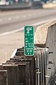
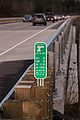
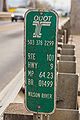
By 2001, ODOT started placing standardized inventory markers at some bridges and overpasses. ODOT's logo is at the top, with a phone number underneath it. Information about the bridge — route number, highway number, milepoint, and ODOT bridge number — is placed in the middle, with the name of the feature being crossed below that. Variations do exist, likely as a result of the contractors used on various projects:
- The "ODOT" in the ODOT logo used to be in Helvetica, but has changed typeface in recent years. All other text is in FHWA Series B, though often times it is condensed even more to fit additional information.
- Phone numbers change depending on the location of the marker and are included as a public safety service. Numbers currently documented include:
- 503-378-2299: 24/7 ODOT Dispatch Center
- 503-283-5859: ODOT Region 1 (Portland Metro Area) Dispatch Center
- 503-362-0457: ODOT Region 2 (NW Oregon) Dispatch Center
- 541-296-2215: ODOT Maintenance District 9 (The Dalles)
- Phone numbers sometimes have dashes in between them.
- Some markers display the text "EMERGENCY ONLY" below the phone number in Series D.
- Interstate routes are displayed with an "I-" in front of the number; by comparison, US and state routes are usually not prefixed by "US" or "OR".
- Milepoints are usually to two decimal points, though some markers exist with only a single decimal point.
- All letters on the markers used to be in all caps; however, the intersecting feature text can sometimes be found in mixed case, such as in markers along the Newberg-Dundee Bypass.
- The text in the intersecting feature section is usually centered, but can sometimes also be left-aligned.
- Milepoints can be negative. If this is the case, they will be displayed with a minus sign in front of the milepoint (e.g. MP -0.52). Negative mileage used to be known as "X-mileage", though there are no known inventory markers that use an "X" instead of a "-".
While many of ODOT's inventory markers legibly display correct information, quite a few do not:
- Some markers place the highway number in the "RTE" section and vice versa – for example, the marker at Mills Bridge on OR-6 displays Route 37 and Highway #6
- Some markers display the wrong route number – for example, the marker on OR-202 across Beneke Creek erroneously displays OR-47 in the "RTE" section
- Some markers on unsigned or formerly-unsigned state routes place the route number in the "RTE" section, but place a condensed abbreviation of the highway name in "HWY" – for example, markers on OR-103 display "Fishhawk F" in illegibly-small condensed Type B
- Some markers display a non-existent route – for example, markers on OR-194 erroneously state they are on "US-51"
- Some markers display redundant information – for example, some markers on OR-18 display the highway number and/or milepoint inside the intersecting feature section in addition to their usual spots

Bridge inventory marker for the Steel Bridge in Portland showing a negative milepoint, 2014
Bridge inventory marker for the I-5 bridge over a Santiam River overflow near the Santiam Rest Area, 2016

Bridge inventory marker for the OR-18 bridge over an unnamed creek near Dundee, 2017

Bridge inventory marker for the SE Parks Road bridge over OR-18 near Dundee, 2018
Bridge inventory marker for the OR-18 bridge over an equipment pass near Dundee, 2018

Bridge inventory marker for the OR-18 bridge over College and River Streets in Newberg, 2018

Bridge inventory marker for Mills Bridge on OR-6 over the Wilson River near Tillamook, 2018
Bridge inventory marker for the US-101 bridge over the Wilson River in Tillamook, 2018

Bridge inventory marker for the original Tide Creek Bridge on former US-30 in Columbia County, 2020
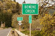
Bridge inventory marker for the OR-202 bridge over Beneke Creek in Jewell, 2020
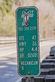
Bridge inventory marker for the Black Bridge on US-26 over the Necanicum River near Cannon Beach Junction, 2021

Bridge inventory marker for the US-197 bridge over the Necanicum River near Cannon Beach Junction, 2021


Culvert and Stormwater Facility Markers
Around 2013, ODOT started placing standardized markers at culverts and stormwater facilities. For culverts, two types of markers are defined in ODOT Standard Drawing RD398, aptly named Type 1 and Type 2.
- Type 1 markers are 4″ × 6–12″ strips of green thermoplastic tape affixed to the road, with no other information added.
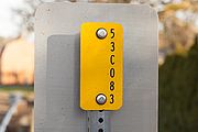
- Type 2 markers are 3½″ × 13¼″ white panels with a green stripe at the top. "ODOT" appears above the stripe. A number appears below the stripe — either the Drainage Facility ID (or "DFI number") if the culvert span is less than 6 feet, or the Bridge Structure ID if the culvert span is between 6 and 20 feet. Below the number is the culvert milepoint. All text on the marker is FHWA Series C, called "Type C font" in the drawing.
Stormwater facilities have three types of markers defined in ODOT Standard Drawing RD399, named Type S1, S2 and S3.
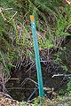
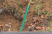
- Type S1 markers are flexible plastic posts embedded into the ground in two colors, red and green. Red posts signify the start of a stormwater facility maintenance area, and green posts signify the end of the maintenance area. Dimensions are the same as ODOT TM570 Type 2 flexible plastic posts, but these omit the 4″ reflective sheeting bands. No other information is added to these posts.
- Type S2 markers are the same size as the Type 2 culvert markers above, and have a similar design. A Type S2's top color band is blue instead of green, and the milepoint is replaced by a 5″ × ¼″ black stripe which can be optionally turned into an arrow to indicate the direction or location of the stormwater facility. Otherwise, both Type 2 and Type S2 display the same information.
- Type S3 markers are essentially DFI numbers stamped onto access covers like manholes and vaults to identify underground stormwater facilities. For durability, ink is not used.
ODOT appears to have used other types of markers to identify and locate culverts and stormwater facilities before; however, their usage appears to be limited, and not much information is known about them:
- Some highways, such as stretches of US-101 and OR-6 near Tillamook, have white paddles with a white button reflector affixed to the top and the milepoint in black Series B towards the bottom. These almost always appear to be found in locations with guardrails and almost always are accompanied by a Type 1 culvert marker on the ground and/or the guardrail. Many of these appear weathered, indicating that they may be years or decades old.
- A section of OR-224 from roughly Carver to Barton has small yellow markers with the milepoint in black FHWA Series C text and a reflective blue circle below. These appear to mark the locations of culverts or other drainage facilities. The milepoints correspond to the mileage along the Clackamas Highway #171.
- A couple highways in the central Willamette Valley (a section of OR-221 south of Dayton, OR-51 in Independence, possibly more) have small, narrow green markers at locations of culverts. A circular ODOT logo is on top with sections below for other information about the culvert, including milepoint, kilometerpoint, diameter in inches, length in feet, type, description, and reference point in feet. An Oregon Utility Notification Center "Stop - Call Before You Dig!" logo is at the bottom. Curiously, many of these markers along OR-221 omit all information except the description (usually "CULVERT"). For comparison, the one along OR-51 in Independence has the information affixed to the post using stickers; the text is white on a green background in FHWA Series B and/or C.

A Type S2 stormwater facility inventory marker at the northern terminus of OR-127 near Linnton, 2021

A yellow culvert marker on OR-224 between Carver and Barton, 2021

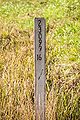
An empty green culvert marker on OR-221 south of Dayton, 2018

A filled-out green culvert marker on OR-51 in Independence, 2022


County Roads
Not all counties place inventory markers on their bridges or at their culverts.

Clackamas County
Clackamas county does not place inventory markers on its bridges, but does place stickers on the back of object markers (such as OM-3L and OM-3R markers) with its ODOT bridge number.
The county also utilizes two different kinds of culvert markers on its roads:
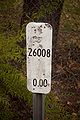
- White metallic rounded rectangles, marked at culverts in hundredths of a mile
- White delineator wickets embedded in the ground, also marked at culverts in hundredths of a mile
Each of these markers contains the mileage in tenths or hundredths of a mile and a 5-digit county road number. This number can sometimes span two different roads if they comprise a longer route, such as Stafford and Wilsonville Roads.
At jurisdictional boundaries, the white markers can also sometimes be found with "BCM" and "ECM", for "begin county maintenance" and "end county maintenance" respectively, depending on the direction of travel. Mileage may be present on the wicket style of "ECM" markers, and the metal rectangle versions of "BCM" markers contain the road number without a milepost (likely because it's implied to be MP 0). Other variants may exist in the wild.
Zero mileposts can be found in both types.
A white rectangular milepost on SW Homesteader Rd. near Stafford, 2013
A white wicket milepost on SE Fireman Way in Boring, 2017
A white rectangular milepost on E Salmon St. near Brightwood, 2017
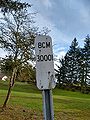
A white "begin county maintenance" marker on SW Ladd Hill Rd. near Sherwood, 2020

A white "begin county maintenance" wicket on SW Carman Dr. in Lake Oswego, 2021

A white "end county maintenance" wicket on SW Carman Dr. in Lake Oswego, 2021


Clatsop County
Clatsop County marks its bridges with a small rectangular inventory marker placed on the bridge itself. These markers display the bridge name, ODOT bridge number, Clatsop County bridge number, and the milepoint in white FHWA Series B text on a green background. They also have a "Clatsop County" stamp on them, similar to mileposts placed on county roads around 2015.
In addition, Clatsop County places street sign blade-sized signs at the bridge itself, mounted on a taller post presumably for motorist assistance. These signs display the waterway name in large text, with the Clatsop County bridge number and bridge name below it in much smaller lettering. All text on this sign is in FHWA Series B. Like the 2015-era mileposts, these also have "Clatsop County" stamped in them, as well as the date of installation written on them in permanent marker; for example, the sign at Humbug Creek was installed in October 2012.
At culverts, Clatsop County uses green wickets with an orange reflective square and the milepoint below in tenths, hundredths or even thousandths of a mile, without identifying any sort of road name or number. The typeface used is a thinner stroke version of Helvetica Inserat Roman.

A bridge inventory marker for the Humbug Bridge over Humbug Creek on Lower Nehalem Road, 2021

A bridge sign for the Humbug Bridge over Humbug Creek on Lower Nehalem Road, 2021

A green wicket culvert marker at MP 9.02 on Lower Nehalem Rd., 2014
A green wicket culvert milepost at MP 5.9 on Hamlet Rd. near Hamlet, 2021

A green wicket culvert milepost at MP 0.157 on Saddle Mountain Road near Olney, 2021
A green wicket culvert milepost at MP 0.009 on Youngs River Road near Olney, 2021


Lincoln County
Lincoln County appears to place bridge markers on its bridges, though the only one currently observed was on the Rocky Creek Bridge on the Otter Crest Loop (old US-101) near Depoe Bay. They are similar in height to ODOT bridge markers, but appear to be narrower. Unlike ODOT markers, they are not reflective, instead featuring a dark green background. In addition, all text on the marker is the same size of yellow-orange FHWA Series B typeface.
These markers have "LINCOLN COUNTY BRIDGE" on top in all caps, and the name of the road (e.g. "Otter Crest Loop") on the bottom in mixed case text. In the middle, various bridge information is present on three lines:
- The top line is the county bridge number, which appears to consist of the county route number, a dash, and a unique identifier (e.g. "311-01").
- The middle line is the ODOT/NBI bridge number, though leading zeroes appear to be dropped.
- The bottom line is the milepost of the bridge.
It is unknown how many bridges in Lincoln County have these markers. It is also unknown how old these markers are; however, since they use lowercase text for the road name, they cannot be older than 2000, when FHWA Series B introduced lowercase characters.
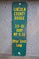
A bridge inventory marker at MP 0.26 on Otter Crest Loop, 2025


Linn County
Linn County places inventory markers on its bridges that displays information like road number, milepoint, bridge number, road name and body of water crossed. These usually appear on both sides of the bridge and use some form of Helvetica for the typeface. Newer versions of these markers use a reflective sheeting, have a border and incorporate rounded corners.
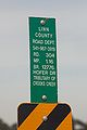
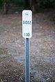
A bridge inventory marker at MP 1.16 on Hofer Road, 2016
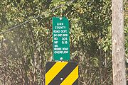
A bridge inventory marker at MP 0.15 on Higbee Road, 2016
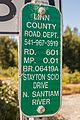
A bridge inventory marker at MP 0.01 on Stayton-Scio Drive, 2024
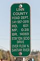
A bridge inventory marker at MP 0.26 on Stayton-Scio Drive, 2024


Marion County
Marion County rarely places inventory markers on its culverts. As of July 2025, the only known marker is placed along Champoeg Rd. NE westbound as it crosses Ryan Creek near Champoeg State Heritage Area. The retroreflective marker has a white background, with sharp points at the corners except for a rounded lower-left corner. What appears to be the culvert's NBIS number is placed vertically in the center in blue FHWA Series C text. No other road, milepoint or structural information can be gleaned from the marker. According to Google Street View, the marker was placed on a wooden post sometime between September 2012 and May 2019.
It is unknown if other markers, or variations of this one, exist in the county, as well as how long these markers have been in use.
An inventory marker for the culvert over Ryan Creek on Champoeg Road NE, 2025


Polk County
Polk County places inventory markers on its bridges, usually just a single marker placed behind one of the diagonally striped hazard signs at the corners of the bridge. This MUTCD yellow-colored marker is about 4 inches wide by 8 inches tall and only displays the bridge's NBIS number vertically on the right side in black FHWA Series B text. No other road, milepoint or structural information can be gleaned from the marker, unless there is information on the back where it cannot easily be seen. It is also unknown if other markers, or variations of this one, exist in the county, as well as how long these markers have been in use.
An inventory marker for the bridge over Baskett Slough at MP 2.31 on Rickreall Road, 2022


Tillamook County
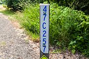
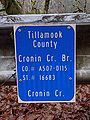
Tillamook County places blue inventory markers on bridges it maintains which list the bridge name, the county bridge number (including the county road number in the first segment), the ODOT bridge number, and the body of water being crossed. All text on the markers is in FHWA Series B. While it isn't known at this time when these markers were placed, their reflective background suggests they may have been placed around the same time as the newer reflective mileposts used on county roads since around 2015.
A bridge inventory marker for the Cronin Creek Bridge on Foss Road, 2021
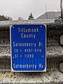
A bridge inventory marker for the Salmonberry Bridge over the Salmonberry River on Foss Road, 2021
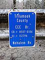
A bridge inventory marker for the CCC Bridge over the Nehalem River on Foss Road, 2021


Washington County
Washington County marks most of its bridges and culverts with markers similar to county road identifiers on mileposts, with the word "ROAD" replaced with "BRIDGE" or "CULVERT" appropriately. The numerals are larger than the road markers, and the legend text appears to be less condensed. Numerals are in Series B, C or D. No other mileage or route identification information can be found on these markers. A newer version of this marker was placed on the Scholls Ferry Road bridge over the Tualatin River when it was replaced in 2008.
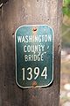
A Washington County bridge marker on Cochran Road near Reehers Camp, 2019

City Roads

Beaverton
The City of Beaverton has placed at least three different versions of small green markers at its bridges:
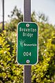
- One (possibly older) version has "Beaverton Bridge" in FHWA Series B on top, the City of Beaverton's centennial seal in the middle, and a white box below containing a green "BB-" (presumably for "Beaverton Bridge") and the bridge number in FHWA Series B on the bottom.
- Another (possibly newer) version retains the same "Beaverton Bridge" on top, but with the City of Beaverton's logo in the middle (omitting the "Oregon") and the bridge number in white FHWA Series C lettering on the bottom.
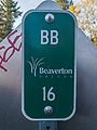
- A third (possibly the newest) version has "BB" (presumably for "Beaverton Bridge") above, the City of Beaverton's logo in the middle (with the "Oregon" this time), and the bridge number below. The "BB" and bridge number are both in white FHWA Series C. The bridge number is also larger than previous versions.
On the first two types of marker, Beaverton appears to use three digits with leading zeroes (e.g. "004") to identify bridges it has built itself; leading zeroes are dropped from the third marker type (e.g. "16"). However, the city may also retain the numbers of bridges it takes over from other jurisdictions. This could be the case with the Johnson Creek Bridge on SW Hart Road, which has the number "19051"; this number more closely resembles those used by Washington County.
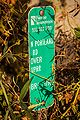
In addition to bridges, Beaverton occasionally places similar markers at its culverts. These markers have the design of the "newest" bridge markers, but with "BC" (presumably for "Beaverton Culvert") on top.
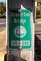
A Beaverton bridge inventory marker with city seal on Broadway, 2021

A Beaverton bridge inventory marker with city seal on SW Village Ln., 2025
A Beaverton bridge inventory marker with city logo on Hall Blvd., 2021
A two-digit Beaverton bridge inventory marker with city logo and "BB" on SW Davis Rd., 2025
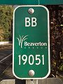
A five-digit Beaverton bridge inventory marker with city logo and "BB" on SW Hart Rd., 2025

A Beaverton culvert inventory marker with city logo on SW Griffith Dr., 2021


Portland
The City of Portland's Bureau of Transportation (PBOT) places inventory markers on many bridges it maintains. These markers feature the logo of either PBOT or its predecessor, the Portland Office of Transportation (PDOT), along with the city's phone number, the road name, the feature it crosses, and a bridge identifier (likely its ODOT number). All text is either FHWA Series B or Series C, aside from the PBOT/PDOT logo which uses condensed versions of both Britannic and Britannic Bold.
In addition, the city's Bureau of Environmental Services (PBES) places markers at culverts. These are white markers with the long edge oriented horizontally. At the top is a blue "City of Portland" in an as-yet unidentified serif font (represented by Goudy Old Style in the example). The PBES logo and city's phone number are on the bottom in the same shade of blue as the "City of Portland" text above. In the middle is presumably the name and some sort of identifier in black Helvetica Bold text.
A PDOT bridge inventory marker on N Portland Road near St. Johns, 2015

A PBES culvert inventory marker near Kelley Point, 2014

