File list
Jump to navigation
Jump to search
This special page shows all uploaded files.
| Date | Name | Thumbnail | Size | User | Description | Versions |
|---|---|---|---|---|---|---|
| 17:30, 4 February 2021 | OR 42S.png (file) |  |
63 KB | Jonathan | Modern shield for OR-42S | 1 |
| 17:30, 4 February 2021 | OR 42.png (file) |  |
47 KB | Jonathan | Modern shield for OR-42 | 1 |
| 17:29, 4 February 2021 | OR 66.png (file) |  |
58 KB | Jonathan | Increased dimensions to 1024x1024 | 2 |
| 16:42, 4 February 2021 | OR 64 1948.png (file) |  |
111 KB | Jonathan | Increased dimensions to 1024x1024 | 2 |
| 16:36, 4 February 2021 | OR 42N 1948.png (file) |  |
97 KB | Jonathan | 1948 version of route shield for OR-42N | 1 |
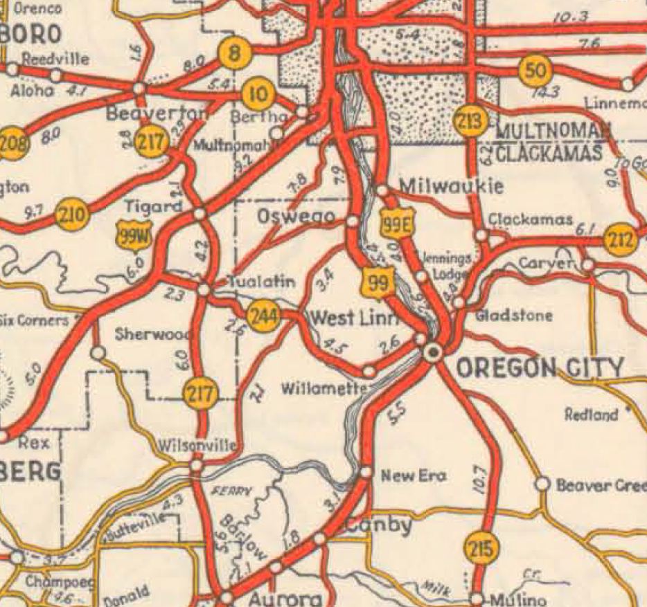
| 01:06, 4 February 2021 | 1936 OfficialMap OregonCity-Wilsonville.png (file) |  |
1.31 MB | Jonathan | A section of the 1936 official Oregon State Highway Map, showing a close-up view of SW/SE Portland, Oregon City, Wilsonville, Beaverton, Oswego, Canby, Tigard, Milwaukie, and other small cities and towns. | 1 |
| 17:30, 2 February 2021 | OR 231 1934-map.jpg (file) |  |
924 KB | Jonathan | Map of the alignment of former OR-231 in 1934. | 1 |
| 23:38, 1 February 2021 | OR 62.png (file) |  |
54 KB | Jonathan | Modern route shield for Oregon Route 62 | 1 |
| 01:30, 1 February 2021 | OR 64-map.jpg (file) |  |
369 KB | Jonathan | Map of the alignment of former OR-64 in 1965. | 1 |