File list
Jump to navigation
Jump to search
This special page shows all uploaded files.
| Date | Name | Thumbnail | Size | Description | Versions |
|---|---|---|---|---|---|
| 02:09, 23 December 2022 | Mp-county-polk-bridge.png (file) |  |
37 KB | An example of a bridge marker found along Polk County roads.<br /> 📷 Jonathan Ledbetter<br /> 📆 23 December 2022 | 1 |
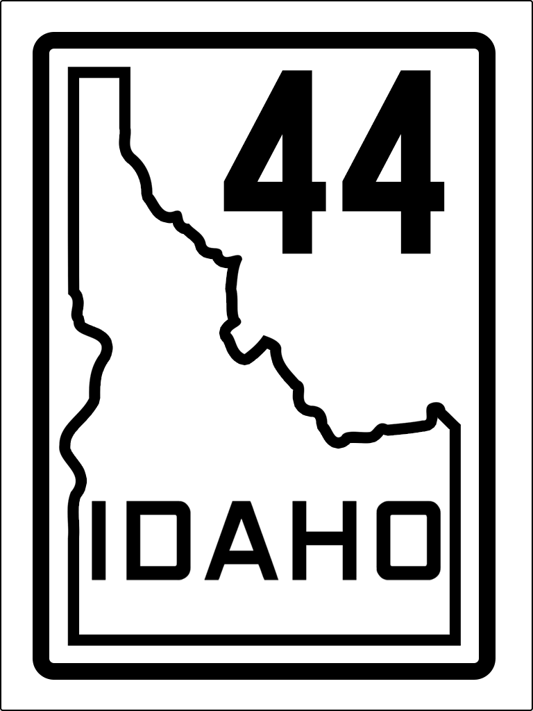
| 18:25, 13 October 2022 | ID 44 1940s.png (file) |  |
33 KB | 1940s version of route shield for Idaho Highway 44 | 1 |
| 10:41, 13 October 2022 | US 30 1926.png (file) |  |
88 KB | 1926 version of shield for US Route 30 | 1 |
| 10:40, 13 October 2022 | US 30N 1926.png (file) |  |
89 KB | 1926 version of shield for US Route 30N | 1 |
| 10:40, 13 October 2022 | US 30S 1926.png (file) |  |
90 KB | 1926 version of shield for US Route 30S | 1 |
| 10:18, 13 October 2022 | OR 226 1932.png (file) |  |
88 KB | 1932 version of route shield for OR-226 | 1 |
| 10:17, 13 October 2022 | OR 222 1932.png (file) |  |
87 KB | 1932 version of route shield for OR-222 | 1 |
| 10:17, 13 October 2022 | OR 228 1932.png (file) |  |
88 KB | 1932 version of route shield for OR-228 | 1 |
| 10:16, 13 October 2022 | OR 201 1932.png (file) |  |
86 KB | 1932 version of route shield for OR-201 | 1 |
| 10:13, 13 October 2022 | OR 27 1932.png (file) |  |
88 KB | 1932 version of route shield for OR-27 | 1 |
| 10:12, 13 October 2022 | OR 14 1932.png (file) |  |
85 KB | 1932 version of route shield for OR-14 | 1 |
| 09:25, 13 October 2022 | US 395 1926.png (file) |  |
89 KB | 1926 version of route shield for US-395 | 1 |
| 09:22, 13 October 2022 | US 28 1926.png (file) |  |
89 KB | 1926 version of route shield for US-28 | 1 |
| 09:21, 13 October 2022 | US 97 1926.png (file) |  |
90 KB | 1927 version of route shield for US-97 | 1 |
| 09:17, 13 October 2022 | US 99W 1926.png (file) |  |
91 KB | 1926 version of route shield for US-99W | 1 |
| 09:16, 13 October 2022 | US 99E 1926.png (file) |  |
89 KB | 1926 version of route shield for US-99E | 1 |
| 00:55, 13 October 2022 | US 20 1948.png (file) |  |
116 KB | 1948 version of route shield for US-20 | 1 |
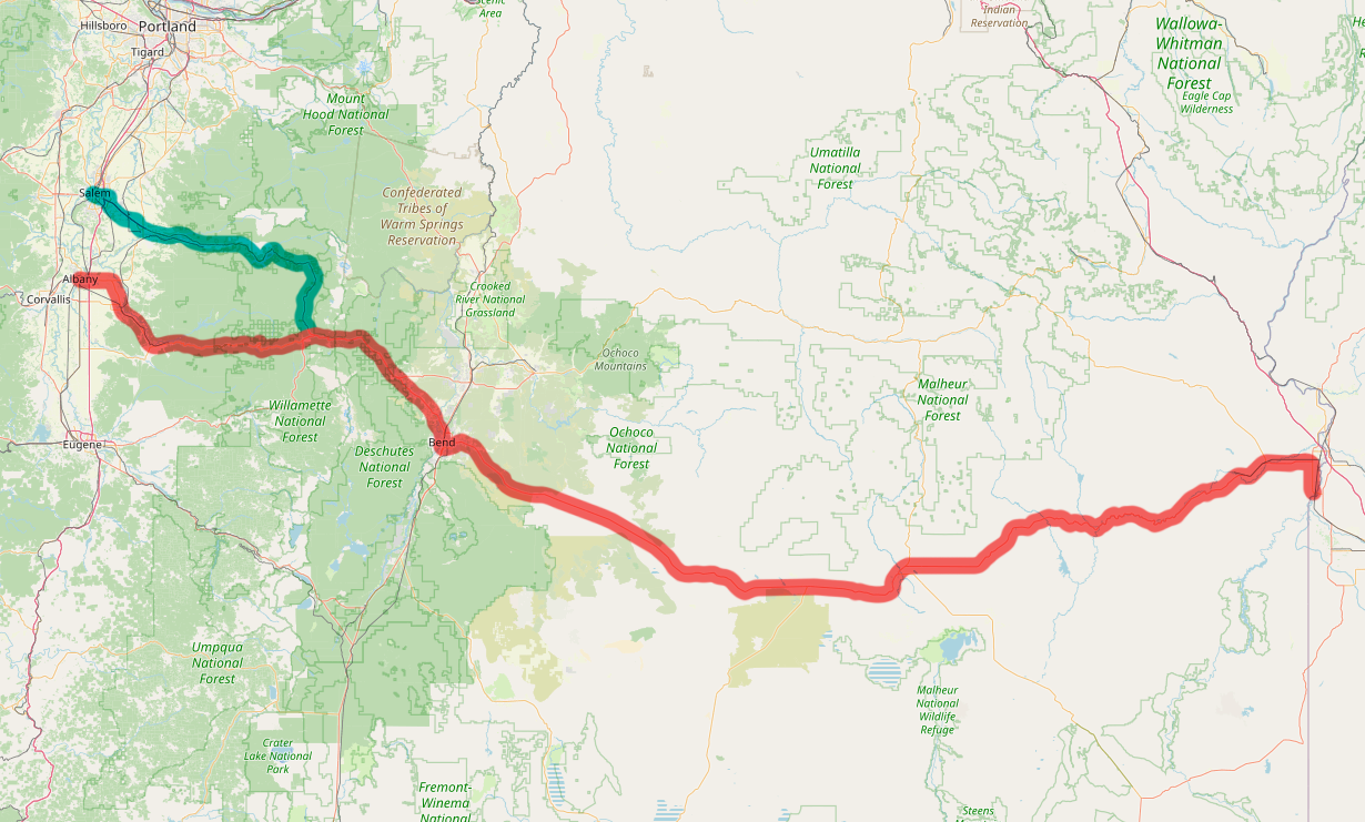
| 00:08, 13 October 2022 | US 14S-map.png (file) |  |
259 KB | Map of proposed US-14S alignment (shown in red) | 1 |
| 00:06, 13 October 2022 | US 14N-map.png (file) |  |
258 KB | Map of proposed US-14N alignment (shown in pink) | 1 |
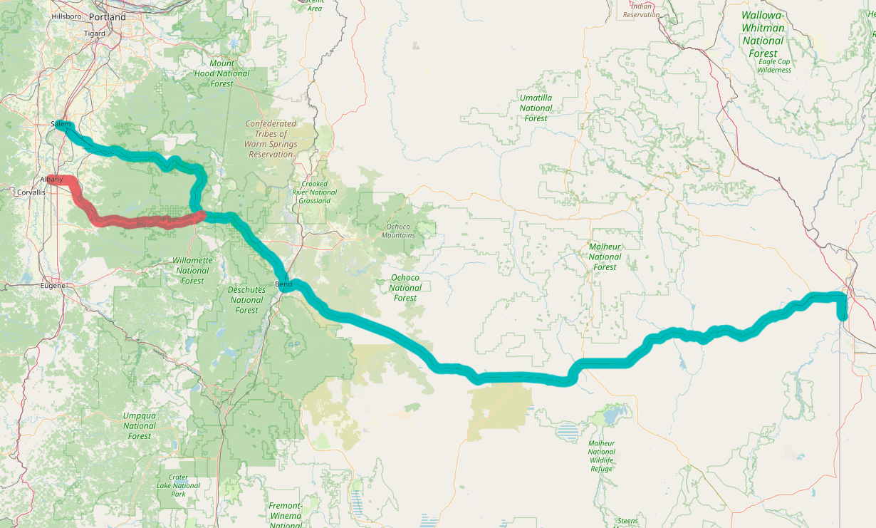
| 00:05, 13 October 2022 | US 14-map.png (file) |  |
684 KB | Map of proposed US-14 alignment | 1 |
| 00:21, 12 October 2022 | US 14S 1926.png (file) |  |
89 KB | 1926 version of shield for US Route 14S | 1 |
| 00:04, 11 October 2022 | US 14N 1926.png (file) |  |
88 KB | 1926 version of shield for US Route 14N | 1 |
| 00:04, 11 October 2022 | US 14 1926.png (file) |  |
87 KB | 1926 version of shield for US Route 14 | 1 |
| 00:01, 11 October 2022 | US 12 1961.png (file) |  |
40 KB | 1961 version of shield for US Route 12 | 1 |
| 00:22, 8 October 2022 | OR 331.png (file) |  |
58 KB | Modern version of route shield for OR-331 | 1 |
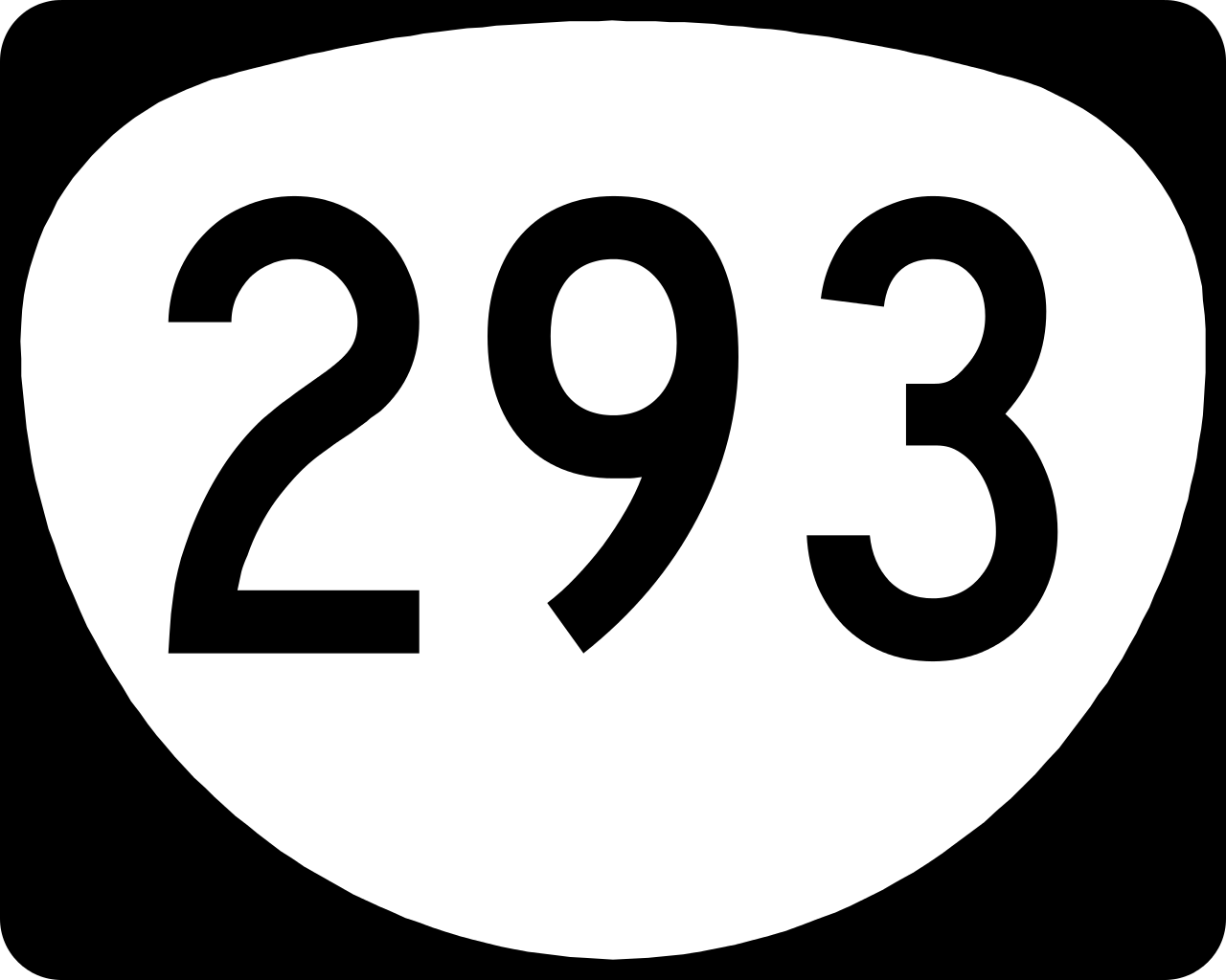
| 00:22, 8 October 2022 | OR 293.png (file) |  |
68 KB | Modern version of route shield for OR-293 | 1 |
| 22:42, 7 October 2022 | OR 226 1948.png (file) |  |
100 KB | 1948 version of route shield for OR-226 | 1 |
| 22:42, 7 October 2022 | OR 214 1948.png (file) |  |
94 KB | 1948 version of route shield for OR-214 | 1 |
| 22:41, 7 October 2022 | OR 219 1948.png (file) |  |
98 KB | 1948 version of route shield for OR-219 | 1 |
| 22:40, 7 October 2022 | OR 221 1948.png (file) |  |
96 KB | 1948 version of route shield for OR-221 | 1 |
| 22:40, 7 October 2022 | OR 223 1948.png (file) |  |
100 KB | 1948 version of route shield for OR-223 | 1 |
| 22:39, 7 October 2022 | OR 51 1948.png (file) |  |
94 KB | 1948 version of route shield for OR-51 | 1 |
| 19:47, 7 October 2022 | By-pass banner.png (file) |  |
33 KB | Modern version of the US and Oregon Route Bypass banner. | 1 |
| 19:46, 7 October 2022 | Business banner.png (file) |  |
18 KB | Modern version of the US and Oregon Route Business banner. | 1 |
| 19:35, 7 October 2022 | OR 22 1948.png (file) |  |
98 KB | 1948 version of route shield for OR-22 | 1 |
| 19:35, 7 October 2022 | OR 18 1948.png (file) |  |
96 KB | 1948 version of route shield for OR-18 | 1 |
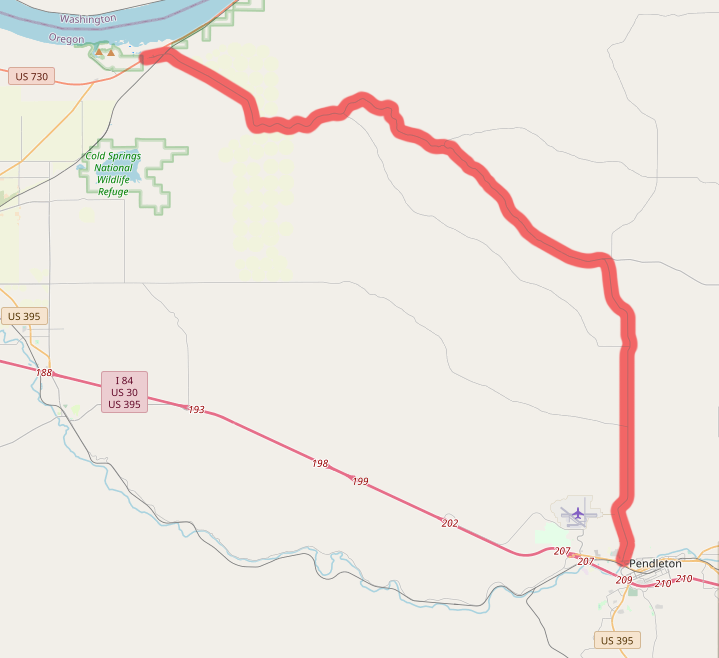
| 00:11, 7 October 2022 | OR 37-map.png (file) |  |
98 KB | Removed part of route that connected to I-84/US-395 | 2 |
| 18:55, 6 October 2022 | US 320-map.png (file) |  |
508 KB | Map of proposed US-320 alignment | 1 |
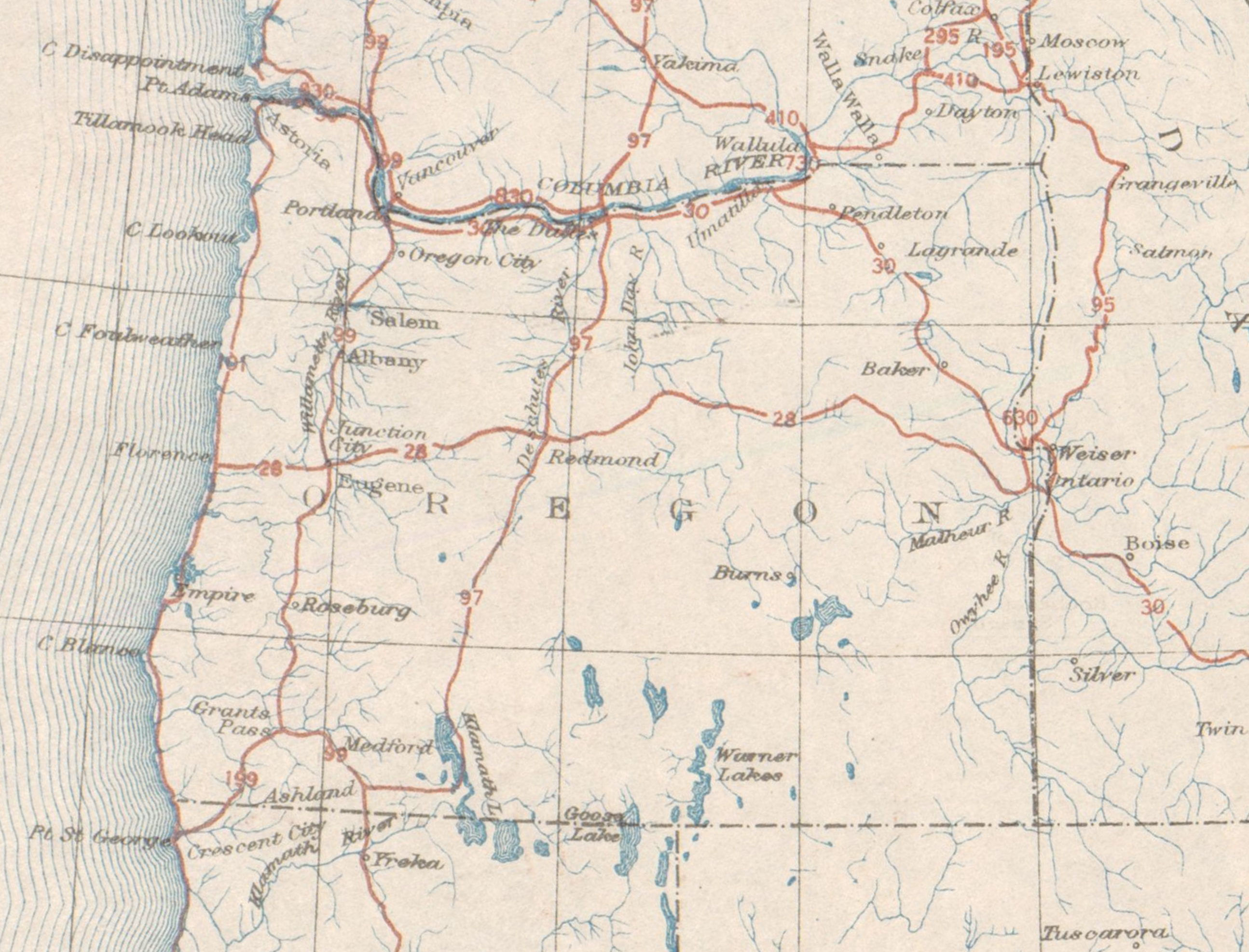
| 17:58, 6 October 2022 | 1926-11-11 AASHO US-Highways-Map Oregon.png (file) |  |
5.51 MB | Map of the United States System of Highways in Oregon, as determined on November 11, 1926. | 1 |
| 17:46, 6 October 2022 | OR 551.png (file) |  |
53 KB | Modern version of route shield for OR-551 | 1 |
| 17:33, 6 October 2022 | US 320 1948.png (file) |  |
117 KB | 1948 version of shield for US Route 320 | 1 |
| 17:31, 6 October 2022 | US 320 1926.png (file) |  |
89 KB | 1926 version of shield for US Route 320 | 1 |
| 16:57, 6 October 2022 | US 630 1926.png (file) |  |
89 KB | 1926 version of shield for US Route 630 | 1 |
| 16:50, 6 October 2022 | OR 69.png (file) |  |
59 KB | Modern version of route shield for OR-69 | 1 |
| 16:47, 6 October 2022 | OR 14 1948.png (file) |  |
100 KB | 1948 version of route shield for OR-14 | 1 |
| 16:20, 6 October 2022 | OR 15 1948.png (file) |  |
104 KB | 1948 version of route shield for OR-15 | 1 |
| 15:10, 6 October 2022 | OR 32 1948.png (file) |  |
111 KB | 1948 version of route shield for OR-32 | 1 |
| 22:40, 5 October 2022 | 1972-12-31 OfficialRouteMap OR-37.png (file) |  |
10 KB | A snippet of the OSHD's "U.S. & Oregon Principal Route Numbers" map dated December 31, 1972 showing OR-37. | 1 |
| 00:19, 30 September 2022 | OR 334.png (file) |  |
62 KB | Modern version of route shield for OR-334 | 1 |
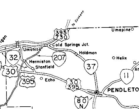
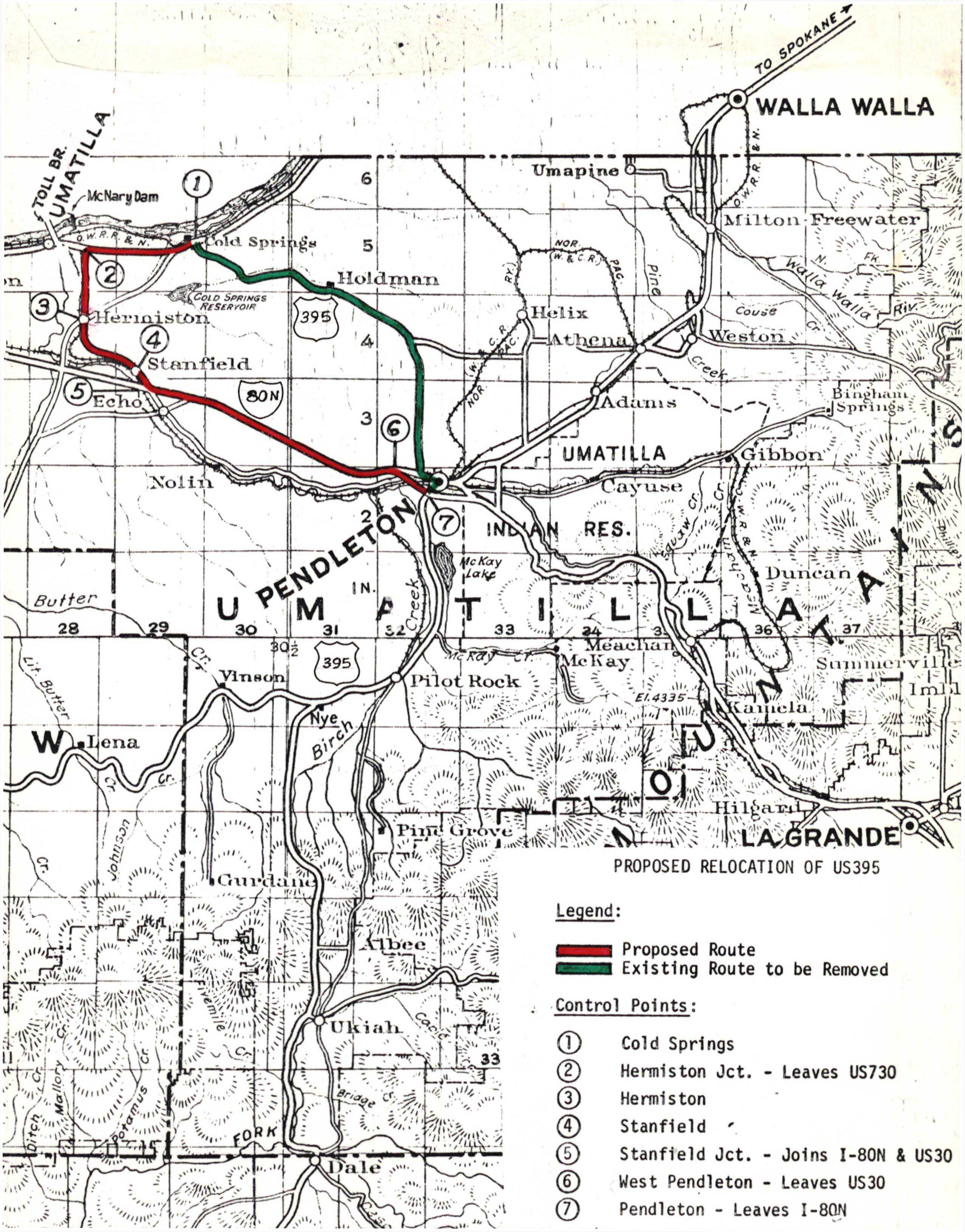
| 14:17, 28 September 2022 | 1972-10-13 OSHD AASHO-US395-app p6.jpg (file) |  |
2.16 MB | The full map on page 6 of the OSHD's 1972 application to AASHO regarding the realignment of US-395. These changes also eliminated OR-32 and created OR-37. Control points referenced on the map:<br /> (1) Cold Springs<br /> (2) Hermiston Jct. - Leaves US730<br /> (3) Hermiston<br /> (4) Stanfield<br /> (5) Stanfield Jct. - Joins I-80N & US30<br /> (6) West Pendleton - Leaves [[US Route 3... | 1 |