File:1955-04 RouteNumbersPrincipalHighways Roseburg.png
Jump to navigation
Jump to search


Size of this preview: 800 × 446 pixels. Other resolutions: 320 × 178 pixels | 914 × 509 pixels.
Original file (914 × 509 pixels, file size: 314 KB, MIME type: image/png)
Summary
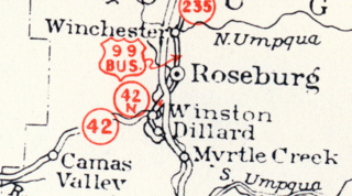
A portion of an April 1955 Oregon state highway map, showing Roseburg and nearby communities.
File history
Click on a date/time to view the file as it appeared at that time.
| Date/Time | Thumbnail | Dimensions | User | Comment | |
|---|---|---|---|---|---|
| current | 17:48, 14 February 2026 | | 914 × 509 (314 KB) | Jonathan (talk | contribs) | A portion of an April 1955 Oregon state highway map, showing Roseburg and nearby communities. |
- You cannot overwrite this file.
File usage
The following page uses this file: