Oregon Route 42N
 |
|||
| Oregon Route 42N | |||
| Coos Bay-Roseburg Highway #35 | |||
 |
|||
| Route Information | |||
|---|---|---|---|
| Maintained by Oregon State Highway Department | |||
| Length | ≈3.77 mi. | ||
| Existed | 1954 to 1956? | ||
| Junctions | |||
| West End | |||
| East End | |||
| Navigation | |||
|
|||
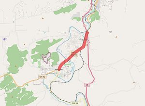
Oregon Route 42N was a primary state route assigned in 1954 between OR-42 in Winston and US-99 in Shady, just south of Roseburg. Designated along what would become an easterly extension of the Coos Bay-Roseburg Highway #35 along a former stretch of US-99/Pacific Highway #1, it was removed from the system sometime between 1956 and 1958.
History
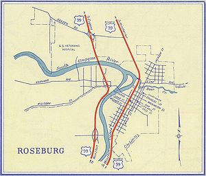
After World War II, Oregon began constructing its two primary US highways, US-99 and US-30, on newer, faster and wider alignments. Many of these new stretches bypassed smaller towns and cities, including Roseburg, Winston and Dillard in Douglas County along US-99. Once these bypasses were constructed and US-99 was moved onto the new alignments of the Pacific Highway, the Oregon State Highway Commission decided to retain the older sections in the highway system, either by creating new secondary highways and routes or by extending primary highways and routes.
In April 1954, the OSHC formally announced its renumbering plans for a few such sections of former US-99 once the new highways opened to the public. Among other items, the Coos Bay-Roseburg Highway was extended northeasterly from its previous terminus in Winston to the new highway in Shady. Curiously, its associated route number, OR-42, was not extended along the same alignment; instead, it was routed southeasterly through Dillard to meet with the new US-99 at Booth Ranch, eventually extending along the Tiller-Trail Highway #230 (replacing OR-227) to the junction of OR-62 at Trail. This left the extension of the Coos Bay-Roseburg Highway without a route number, so the commission decided to assign it OR-42N[1]:
Highway reconstruction in Oregon will result in changes in route numbers, it is announced by the Oregon Highway Commission. As new highway sections are completed and put into use, new titles will be adopted. Changes will start during the summer.
Several Douglas County roads are affected. ... Another announced change brings the Tiller-Trail Cut-Off into the system as an extension of the Roseburg-Coos Bay Highway. The road from Winston to Coquille now is known as State Highway 42. This route is to be extended eastward over the old Pacific Highway from Winston through Myrtle Creek to Canyonville and east from Canyonville through Tiller to Trail. The section from Winston to Roseburg, following the present highway, which is to be bypassed, will be known as S.H. 42N.
- Roseburg News-Review, "Reconstruction of Highway Through Oregon to Result in Route Number Changes," April 8, 1954
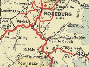
The change to OR-42 can be seen in the 1955 official state highway map, but a shield for OR-42N is not shown due to the small amount of space available to place it. In addition, Roseburg didn't have a city inset on the state map until the following year, and the portion covered was too far north to see the junction where OR-42N terminated.
Around 1956, the state highway commission decided to cosign a bunch of US-99 Business routes south of Eugene along the former US-99 alignments that had received state route numbers in 1954. Roseburg was no different; its business route started to the north in Winchester, then travelled along OR-235 (another 1954 designation) through Roseburg, Shady (where OR-235 terminated), Winston and Dillard to end at Booth Ranch. Despite the new US-99 Business designations, most of the 1954 state route designations lasted until at least 1962. OR-42N is the exception on the shorter end; it may have been removed from the system around 1956 or 1957, the latter year being when the new US-99 section from Shady to Booth Ranch opened to traffic. It was left off a list of US and state route descriptions published in December 1958 — the route descriptions of OR-42[2] and the Roseburg US-99 Business[3] would have listed OR-42N at intersections or along cosigned portions (bolded below), but neither do:
ORE42 –
Over the Coos Bay-Roseburg Highway from its junction with the Oregon Coast Highway, US101, in Coquille, easterly via Myrtle Point, Remote and Camas Valley to its junction with the Dillard Highway, US99 Business, at Winston; thence over the Dillard Highway, US99 Business, to its junction with the Pacific Highway, US99, at Booth Ranch; thence over the Pacific Highway, US99, to its junction with the Myrtle Creek Highway north of Myrtle Creek; thence southerly over the Myrtle Creek Highway via Myrtle Creek to its junction with the Pacific Highway, US99, at Riddle Junction; thence over the Pacific Highway, US99, to its junction with the Tiller-Trail Highway north of Canyonville; thence southeasterly and easterly over the Tiller-Trail Highway via Days Creek and Tiller to its junction with the Crater Lake Highway, ORE62, at Trail.
-From "Description of US and ORE Numbered Highway Routes," December 1958, p. 16
US99 – Business (Roseburg)
Over the connection with the Pacific Highway, US99, at Winchester, to its junction with the Oakland-Shady Highway, ORE235; thence southerly over the Oakland-Shady Highway, ORE235, via Roseburg to its junction with the Coos Bay-Roseburg Highway at Shady; thence southwesterly over the Coos Bay-Roseburg Highway to its junction with the Dillard Highway, ORE42, in Winston; thence southerly over the Dillard Highway to its junction with the Pacific Highway, US99, at Booth Ranch, approximately five miles north of Myrtle Creek.
-From "Description of US and ORE Numbered Highway Routes," December 1958, p. 10
More research is needed to build a more accurate timeline of this route.
Rediscovery
Long forgotten after its brief lifespan in the 1950s, OR-42N was rediscovered on the AARoads roadgeek forum on September 30, 2016 after user CGPerry posted a photo of a wooden OR-42N shield he purchased at an antiques store in Salem[4]. The shield looks a little weathered but appeared in good shape, suggesting that OR-42N was indeed signed along that stretch of the Coos Bay-Roseburg Highway.
References
- ↑ Roseburg News-Review. "Reconstruction of Highway Through Oregon to Result in Route Number Changes," 8 April 1954, pp. 1-2
- ↑ Oregon State Highway Department. "Description of US and ORE Numbered Highway Routes," December 1958, p. 16
- ↑ Oregon State Highway Department. "Description of US and ORE Numbered Highway Routes," December 1958, p. 10
- ↑ Perry, Curtis Gregory [CGPerry]. Oregon 42N, AARoads, 30 September 2016, https://www.aaroads.com/forum/index.php?topic=18931.0, last accessed 5 February 2021


