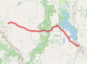
Oregon Route 64
 |
|||
| Oregon Route 64 | |||
| Lake of the Woods Highway #270 | |||
 |
|||
| Route Information | |||
|---|---|---|---|
| Maintained by Oregon State Highway Department | |||
| Length | ≈65.64 mi. | ||
| Existed | June 1, 1965 to December 14, 1965 | ||
| Junctions | |||
| West End | |||
| East End | |||
| Navigation | |||
|
|||
Oregon Route 64 was a short-lived primary state route that ran between OR-62 in Eagle Point and US-97 in Klamath Falls. It was designated along the Lake of the Woods Highway #270 in 1965 for less than 6 months before being renumbered OR-140 that same year.
Contents
History
Highway History Prior to Designation
The Lake of the Woods Highway was originally designated by the State Highway Commission on November 13, 1931 as the Little Butte Highway #270 between Eagle Creek and the Jackson/Klamath County Line and the southernmost portion of the Klamath Lake Highway #421 between Lake of the Woods Junction (near Rocky Point) and Klamath Falls[1], with a section of forest road (Lake of the Woods County Road) in between. On October 23, 1958, the Commission combined the aforementioned highways and county roads into the Lake of the Woods Highway #270[2].
Route History Prior to Designation
When the secondary state route system was introduced around 1934, the combination of the Little Butte Highway, Lake of the Woods County Road and southern portion of the Klamath Lake Highway were designated OR-236[3]:
Ore. 236 Beginning at a junction with Ore. 62 at Eagle Point; thence east on secondary #270 to Klamath County Line; thence east on Forest Road to junction with secondary #421; thence south on secondary #421 to a junction with U. S. 97 in Klamath Falls.
-From "Oregon State Highway Department Designated Route Numbers," c. 1934, p. 3
On official Oregon highway maps, OR-236 appeared from 1936 (along with the other secondary routes signed at the time) through 1945; it was omitted starting with the 1946 edition of the map. OR-236 was also removed from the highway department's list of route descriptions between May 1943[4] and December 1958[5].
By 1963, former OR-236 was included as part the "Winnemucca to the Sea Highway", a proposal from the Winnemucca to the Sea Highway Association to connect Crescent City, California to Winnemucca, Nevada by way of Grants Pass, Medford, Klamath Falls and Lakeview in Oregon[6]. That year, the State Highway Commission was receptive to their proposal, approving US-140 on April 25, 1963 pending approval from AASHO[7]. However, State Highway Engineer Forrest Cooper's application to AASHO for the change was rejected twice — once in May 1963 due to Nevada's failure to submit their own application for US-140[8], and another in October 1963 because the proposed route did not meet AASHO standards[9].
Lifespan as OR-64
Undeterred, Cooper recommended on June 1, 1965 that the Oregon State Highway Commission designate a state route number to the portion of rejected US-140 that ran along the Lake of the Woods Highway, suggesting OR-64[10]:
Because of recent improvements to the Lake of the Woods Highway, the Engineer recommended that it be designated as route ORE64. The Commission approved the designation as follows:
ORE 64 over the Lake of the Woods Highway, from its junction with the Crater Lake Highway, ORE 62, near Eagle Point, to its junction with The Dalles-California Highway, US97, in Klamath Falls.
-OSHC Minutes, 1965-06-01, pp. 34326-27
This designation would not last long. Cooper later received a request that the Winnemucca to the Sea Highway within the state of Oregon be given a single route number. (The party requesting the single designation was not disclosed.) In keeping with the previous US-140 proposal, he recommended on December 14, 1965 that the State Highway Commission eliminate OR-64 in favor of a westerly extension of OR-140; the latter route was originally designated on July 13, 1965 from the junction of US-395 and OR-66 in Lakeview to the Nevada State Line. In doing so, the eastern terminus of OR-66 was truncated from Lakeview to Klamath Falls[11].
The Commission also approved the elimination of ORE64 previously routed over the Lake of the Woods Highway between Eagle Point and Klamath Falls.
-OSHC Minutes, 1965-12-14, p. 34514
Legacy
OR-64 is one of the shortest-lived, if not the shortest-lived, state routes in Oregon's history. Because it only lasted for just under 6 months, it is unknown at this time if OR-64 was ever signed in the wild. It does not appear on the official Oregon state highway maps for 1965 or 1966 — the Lake of the Woods Highway is unnumbered on the 1965 map and numbered OR-140 in the 1966 map. Also, no known 1965 commercial maps show the route.
Rediscovering Former OR-64
Coming soon.
References
- ↑ Oregon State Highway Commission minutes, 13 November 1931, p. 3133-36
- ↑ Oregon State Highway Commission minutes, 23 October 1958
- ↑ Oregon State Highway Department. "Designated Route Numbers," c. 1934, p. 3
- ↑ Oregon State Highway Department. "Description of US and ORE Numbered Highway Routes, Revision 1," 10 May 1943, p. 16
- ↑ Oregon State Highway Department. "Description of US and ORE Numbered Highway Routes," December 1958, p. 25
- ↑ Kerr, Doug. "Gribblenation: Winnemucca to the Sea Highway," 10 April 2020, last accessed 2 February 2021
- ↑ Oregon State Highway Department application to AASHO to establish US-140, p. 2
- ↑ A. E. Johnson (AASHO) letter to W. Otis Wright (Nevada Department of Highways), 21 May 1963
- ↑ A. E. Johnson (AASHO) letter to W. Otis Wright (Nevada Department of Highways), 14 November 1963
- ↑ Oregon State Highway Commission minutes, 1 June 1965, pp. 34326-27
- ↑ Oregon State Highway Commission minutes, 14 December 1965, pp. 34512-14